IMAGES TAKEN NEAR TO
Dallowgill, RIPON, HG4 3RH
Introduction
This page details the photographs taken nearby to Dallowgill, HG4 3RH by members of the Geograph project.
The Geograph project started in 2005 with the aim of publishing, organising and preserving representative images for every square kilometre of Great Britain, Ireland and the Isle of Man.

There are currently over 7.5m images from over14,400 individuals and you can help contribute to the project by visiting https://www.geograph.org.uk
Image Map
Images are licensed for reuse under creativecommons.org/licenses/by-sa/2.0
Notes
- Clicking on the map will re-center to the selected point.
- The higher the marker number, the further away the image location is from the centre of the postcode.
Image Listing (15 Images Found)
Images are licensed for reuse under creativecommons.org/licenses/by-sa/2.0
Image
Details
Distance
1
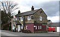
The Drovers Inn
Generally known amongst locals as the 'Little Drovers' to distinguish it from the Drovers at Bishop Thornton Image which is currently in a very poor state.
The Drovers stands close to the moor edge on an old market road between Pateley Bridge and Kirkby Malzeard where there was once an important market. I believe this is the only pub in North Yorkshire with a 24 hour licence, but don't turn up here at three in the morning expecting a drink!
2014 update: The 'Little Drovers' has now gone, having burnt down some two years ago.
Image: © Gordon Hatton
Taken: 14 Apr 2008
0.00 miles
2
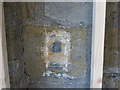
The original location of the now re-sited Ordnance Survey Flush Bracket 11573
The wall of the former Drovers Inn.
For more detail see : http://www.bench-marks.org.uk/bm22378
Image: © Peter Wood
Taken: 2 Sep 2014
0.02 miles
3
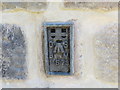
Ordnance Survey Flush Bracket 11573
This re-sited Bracket can be found on the wall of a newly extended building at The Moorhouse - formerly the Drovers Inn.
For more detail see : http://www.bench-marks.org.uk/bm22378
Image: © Peter Wood
Taken: 2 Sep 2014
0.03 miles
4
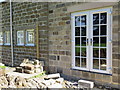
New Building at the former Drovers Inn
The re-position Ordnance Survey Flush Bracket 11573 is visible on the new wall.
For more detail see : http://www.bench-marks.org.uk/bm22378
Image: © Peter Wood
Taken: 2 Sep 2014
0.03 miles
5
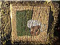
Mosaic outside Drovers Inn
The Drovers Inn sits on the corner of four squares. This mosaic is placed to the north east of the pub so slips into SE2172 by a few yards. Someone has gone to a lot of trouble to create this art.
Image: © Chris Heaton
Taken: 6 Dec 2005
0.03 miles
6
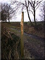
Signpost Abuse
Looking forlorn, little remains of this signpost that was mangled by a flail hedgecutter, on Wetshod Lane... part of the Ripon Rowel Route.
I have reported the state of this signpost to the local authority & hope they will replace it.
Image: © Matthew Hatton
Taken: 16 Dec 2007
0.04 miles
7
Start of Belford Lane
Looking along Belford Lane from the T junction.
Image: © DS Pugh
Taken: 15 Apr 2022
0.11 miles
8
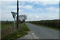
Junction with Belford Lane
Looking along the road towards Laverton.
Image: © DS Pugh
Taken: 15 Apr 2022
0.13 miles
9
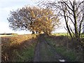
Westhood Lane
Green Lane that leads south from the Drovers' Inn - the only pub I know that fits into 4 geograph squares
Image: © Chris Heaton
Taken: 6 Dec 2005
0.16 miles
10
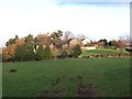
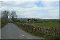
Hogerston Hill
The buildings of Hogerston Hill taken from Belford Lane
Image: © Chris Heaton
Taken: 6 Dec 2005
0.17 miles