IMAGES TAKEN NEAR TO
North Stainley, RIPON, HG4 3HQ
Introduction
This page details the photographs taken nearby to HG4 3HQ by members of the Geograph project.
The Geograph project started in 2005 with the aim of publishing, organising and preserving representative images for every square kilometre of Great Britain, Ireland and the Isle of Man.

There are currently over 7.5m images from over14,400 individuals and you can help contribute to the project by visiting https://www.geograph.org.uk
Image Map (Loading...)


Getting Data...Please wait
Leaflet Map data © OpenStreetMap
Images are licensed for reuse under creativecommons.org/licenses/by-sa/2.0
Notes
- Clicking on the map will re-center to the selected point.
- The higher the marker number, the further away the image location is from the centre of the postcode.
Image Listing (18 Images Found)
Images are licensed for reuse under creativecommons.org/licenses/by-sa/2.0
Image
Details
Distance
1
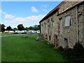
Sleningford Water Mill
Now appears to be used for storing canoes, for use on the nearby River Ure - and part of the Sleningford Watermill Caravan and Camping Park.
Image: © Chris Heaton
Taken: 16 Aug 2013
0.01 miles
2
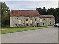
Sleningford Watermill
Former watermill, now on the site of a camping & caravan park.
Image: © David Robinson
Taken: 21 Sep 2021
0.02 miles
3
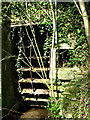
Old Wheel
Neglected at Sleningford Water Mill.
Image: © David Rogers
Taken: 4 Apr 2009
0.02 miles
4
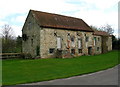
Sleningford Water Mill
On the banks of the River Ure downstream from West Tanfield. It may have been called Walk Mill in the 1850's.
Image: © David Rogers
Taken: 4 Apr 2009
0.03 miles
5
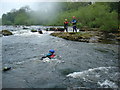
Swiftwater rescue at Sleningford
Sleningford Watermill is a favourite place for canoeists to train, as it has rapids which run in summer, and agreed access despite the fishing season. Here Martyn Hartley is teaching swiftwater rescue techniques including the use of throwlines and defensive swimming techniques.
Image: © Andy Waddington
Taken: 14 May 2006
0.08 miles
6
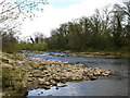
River Ure
Looking upstream near the canoeing centre at Sleningford Water Mill.
Image: © David Rogers
Taken: 4 Apr 2009
0.09 miles
7
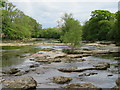
The Ure at Sleningford
Just upstream from Sleningford Mill where the river winds its way through and over areas of flat limestone. This is not the Carboniferous Limestone of the Dales, but part of the thin strip of Permian [Magnesian] Limestone that runs from Derbyshire to County Durham and which can be seen more locally at Knaresborough where the Nidd runs through a limestone and sandstone gorge.
Image: © Gordon Hatton
Taken: 13 May 2020
0.14 miles
9
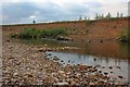
River Ure
A gentle flow during the summer. More torrential flows of the past are evidenced by the erosion on the opposite bank.
Image: © Mick Garratt
Taken: 10 Jun 2011
0.17 miles
10
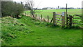
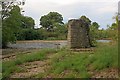
Ure Footpath
As the river bank erodes so the footpath has to be moved. It now follows a line through the new gate and the other side of the fence.
Image: © David Rogers
Taken: 4 Apr 2009
0.18 miles