IMAGES TAKEN NEAR TO
Shirley Avenue, RIPON, HG4 1SP
Introduction
This page details the photographs taken nearby to Shirley Avenue, HG4 1SP by members of the Geograph project.
The Geograph project started in 2005 with the aim of publishing, organising and preserving representative images for every square kilometre of Great Britain, Ireland and the Isle of Man.

There are currently over 7.5m images from over14,400 individuals and you can help contribute to the project by visiting https://www.geograph.org.uk
Image Map (Loading...)


Getting Data...Please wait
Leaflet Map data © OpenStreetMap
Images are licensed for reuse under creativecommons.org/licenses/by-sa/2.0
Notes
- Clicking on the map will re-center to the selected point.
- The higher the marker number, the further away the image location is from the centre of the postcode.
Image Listing (85 Images Found)
Images are licensed for reuse under creativecommons.org/licenses/by-sa/2.0
Image
Details
Distance
1
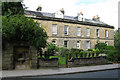
Borrage Terrace, Ripon
Grade II listed terrace; probably early C19, perhaps late C18. Richardson's Drinking Fountain is in the foreground. Image
Image: © David Rogers
Taken: 9 Sep 2010
0.04 miles
2
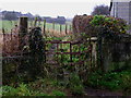
Towards Hell Wath
Beside the River Skell on Borrage Green Lane.
Image: © David Rogers
Taken: 12 Dec 2009
0.04 miles
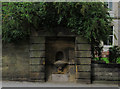
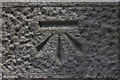
3
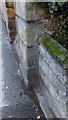
Benchmark on Richardson's Drinking Fountain
Also known as Borrage Well. Marked as being at a height of 96.0' c.1909.
Image: © Matthew Hatton
Taken: 24 Dec 2015
0.06 miles
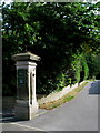
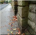
4
Harrogate Road Bench Mark
Located on the stone pillar at the entrance to South Crescent. Old maps show height as 102(feet) but this cut mark does not appear to be included on the current Ordnance Survey database. Image
Image: © David Rogers
Taken: 6 Sep 2010
0.06 miles
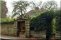
5
South Crescent, Ripon
Near the base of the pillar at the entrance to this private road there is a bench mark; Image
Image: © David Rogers
Taken: 6 Sep 2010
0.06 miles
6
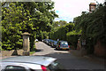
South Crescent
Looking across Harrogate Road to the entrance pillars of South Crescent. There is a cut bench mark on the left pillar and a closer view can be seen here: Image
Image: © Mark Anderson
Taken: 24 Jun 2012
0.06 miles
7
Richardson's Drinking Fountain
Grade II listed drinking fountain beside Borrage Terrace on Harrogate Road. Image The inscription on the pediment reads, "THIS WELL WAS GIVEN FOR THE USE OF THE PUBLIC BY W RICHARDSON ESQ MD 1758". Limited research suggests that William Richardson was born in 1709 and died in 1783. Image
Image: © David Rogers
Taken: 9 Sep 2010
0.07 miles
8
Ripon, Harrogate Road
There is a benchmark cut into the roadside well surround on the west side of the A61, Harrogate Road, as approach Ripon city centre.
Image: © Mel Towler
Taken: 27 Oct 2022
0.07 miles
9
Ripon, Harrogate Road
The benchmark is cut into the roadside well surround on the west side of the A61, Harrogate Road, as approach Ripon city centre.
Image: © Mel Towler
Taken: 27 Oct 2022
0.07 miles
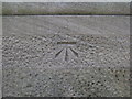
10
Cut Bench Mark, South Crescent
Bench Mark Database: http://www.bench-marks.org.uk/bm43628
Image: © Mark Anderson
Taken: 24 Jun 2012
0.07 miles