IMAGES TAKEN NEAR TO
Princess Place, RIPON, HG4 1HR
Introduction
This page details the photographs taken nearby to Princess Place, HG4 1HR by members of the Geograph project.
The Geograph project started in 2005 with the aim of publishing, organising and preserving representative images for every square kilometre of Great Britain, Ireland and the Isle of Man.

There are currently over 7.5m images from over14,400 individuals and you can help contribute to the project by visiting https://www.geograph.org.uk
Image Map (257 Images)


Getting Data...Please wait
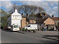
Leaflet Map data © OpenStreetMap
Images are licensed for reuse under creativecommons.org/licenses/by-sa/2.0
Notes
- Clicking on the map will re-center to the selected point.
- The higher the marker number, the further away the image location is from the centre of the postcode.
Image Listing (257 Images Found)
Images are licensed for reuse under creativecommons.org/licenses/by-sa/2.0
Image
Details
Distance
1
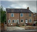
Ripon, Princess Road
According to the OS benchmark database there was a benchmark cut into a post with the boundary wall of no. 18. The terrace has undergone redevelopment with a widened gateway and a new front wall. The benchmark wasn't found.
Image: © Mel Towler
Taken: 28 Sep 2022
0.02 miles
2
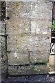
Benchmark on gatepost at entrance to #3 Princess Road
Ordnance Survey cut mark benchmark described on the Bench Mark Database at http://www.bench-marks.org.uk/bm48406
Image: © Roger Templeman
Taken: 10 May 2013
0.02 miles
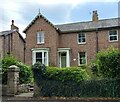
3
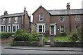
#3 Princess Road
There is an OS benchmark Image at the base of the left hand gatepost at the stepped entrance to the house
Image: © Roger Templeman
Taken: 10 May 2013
0.02 miles
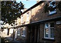
5
Ripon, 3 Princess Road
The benchmark is cut into the left hand gatepost of the above property.
Image: © Mel Towler
Taken: 28 Sep 2022
0.06 miles
6
Ripon, 3 Princess Road
There is a benchmark cut into the left hand gatepost of the above property.
Image: © Mel Towler
Taken: 28 Sep 2022
0.06 miles
7
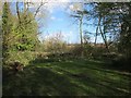
Princess Road public open space, Ripon (2)
A clearing at the eastern end of the site. The whole site comprises 4 acres (1.6ha) of mostly wooded land, owned by Harrogate Borough Council and open to the public.
Image: © Stephen Craven
Taken: 2 May 2016
0.08 miles
8
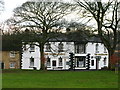
The Magdalens
View from Paddies Park of the public house at the corner of Stonebridgegate and Princess Road.
Image: © David Rogers
Taken: 24 Jan 2010
0.09 miles
9
Magdalen's, Stonebridgegate, Ripon
This is the rear of the pub, with car park. For the front, see Image The pub is presumably named after the nearby church of St Mary Magdalen Image
Image: © Stephen Craven
Taken: 2 May 2016
0.10 miles
10
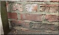
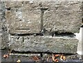
Ripon, Magdalen Road
The remains of 2 legs of a benchmark arrowhead can be seen to the right of the wooden post, and on the 2nd course of bricks.
Image: © Mel Towler
Taken: 28 Sep 2022
0.10 miles