IMAGES TAKEN NEAR TO
North Road, RIPON, HG4 1FD
Introduction
This page details the photographs taken nearby to North Road, HG4 1FD by members of the Geograph project.
The Geograph project started in 2005 with the aim of publishing, organising and preserving representative images for every square kilometre of Great Britain, Ireland and the Isle of Man.

There are currently over 7.5m images from over14,400 individuals and you can help contribute to the project by visiting https://www.geograph.org.uk
Image Map (Loading...)


Getting Data...Please wait
Leaflet Map data © OpenStreetMap
Images are licensed for reuse under creativecommons.org/licenses/by-sa/2.0
Notes
- Clicking on the map will re-center to the selected point.
- The higher the marker number, the further away the image location is from the centre of the postcode.
Image Listing (138 Images Found)
Images are licensed for reuse under creativecommons.org/licenses/by-sa/2.0
Image
Details
Distance
1
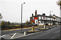
The Station, Ripon
A closed pub. There used to be a railway a little to the east. On the left of this view is the profile of the Minster.
Image: © Bill Boaden
Taken: 11 Nov 2011
0.02 miles
3
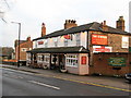
The Station public house.
The pub is situated in North Road some 500 yds from the site of the old railway station.
Now closed [2014] and derelict, possibly awaiting demolition.
Image: © Gordon Hatton
Taken: 30 Dec 2007
0.02 miles
4
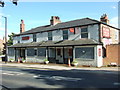
The Station Hotel - now closed
This pub closed in mid 2011 and has now (July 2011) been boarded up. There is another photograph for this square showing it in better days.
Image: © C P Smith
Taken: 6 Jul 2011
0.02 miles
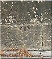
5
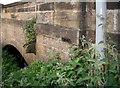
Ure Flood Levels
River levels on the Ure have been recorded on North Bridge at Ripon. The metal plate shows the flood level on 24-02-91, while inscribed beyond is the water level on January 29th 1883. Another older inscription denotes a lower flood level but the letters are worn. Image
Image: © David Rogers
Taken: 8 Jun 2008
0.02 miles
6
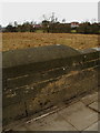
North Bridge bench mark
Cut mark at 22.9722 metres. The horizontal cut is offset, possibly following previous repairs to the bridge.
Image: © David Rogers
Taken: 17 Mar 2010
0.02 miles
7
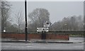
Old signpost, North Rd
The road is now the A6108 not the A61.
Image: © N Chadwick
Taken: 30 Dec 2015
0.03 miles
8
Flood Level, River Ure, North Bridge, Ripon, 06/12/15
The level of this flood falls just short of those recorded on 24/2/1991(black metal plate) and 29/01/1883 (chiselled in stone). Image
Image: © David Rogers
Taken: 6 Dec 2015
0.04 miles
9
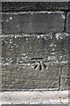
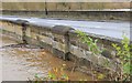
Benchmark on wall of North Road near North Bridge
Ordnance Survey cut mark benchmark described on the Bench Mark Database at http://www.bench-marks.org.uk/bm32556
Image: © Roger Templeman
Taken: 7 May 2013
0.04 miles
10
Ripon, North Road
The benchmark is cut into the roadside wall on the north-west side of North Road.
Image: © Mel Towler
Taken: 28 Sep 2022
0.04 miles