IMAGES TAKEN NEAR TO
Primrose Close, RIPON, HG4 1EH
Introduction
This page details the photographs taken nearby to Primrose Close, HG4 1EH by members of the Geograph project.
The Geograph project started in 2005 with the aim of publishing, organising and preserving representative images for every square kilometre of Great Britain, Ireland and the Isle of Man.

There are currently over 7.5m images from over14,400 individuals and you can help contribute to the project by visiting https://www.geograph.org.uk
Image Map (113 Images)


Getting Data...Please wait
Leaflet Map data © OpenStreetMap
Images are licensed for reuse under creativecommons.org/licenses/by-sa/2.0
Notes
- Clicking on the map will re-center to the selected point.
- The higher the marker number, the further away the image location is from the centre of the postcode.
Image Listing (113 Images Found)
Images are licensed for reuse under creativecommons.org/licenses/by-sa/2.0
Image
Details
Distance
1
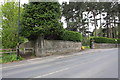
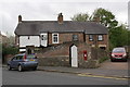
Junction of footpath with road at #36 Palace Road
There is an OS benchmark Image on the road face of the wall corner pier on the right hand side of the footpath
Image: © Roger Templeman
Taken: 10 May 2013
0.06 miles
2
Ripon, Palace Road
The benchmark is cut into the face of a large stone post on the west side of Palace Road. The post is to the north of the start of a footpath.
Image: © Mel Towler
Taken: 18 Nov 2022
0.06 miles
3
Ripon, Palace Road
There is a benchmark cut into the face of a large stone post on the west side of Palace Road. The post is to the north of the start of a footpath.
Image: © Mel Towler
Taken: 18 Nov 2022
0.06 miles
4
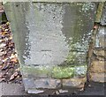
Benchmark on boundary wall corner pier of #36 Palace Road
The Ordnance Survey cut mark benchmark is described on the Bench Mark Database at http://www.bench-marks.org.uk/bm48404
Image: © Roger Templeman
Taken: 10 May 2013
0.07 miles
5
#30 Palace Road
There is an OS benchmark Image below the EIIR letter box, right of the white gate
Image: © Roger Templeman
Taken: 10 May 2013
0.08 miles
6
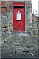
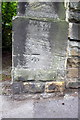
Benchmark below letter box outside #30 Palace Road
Ordnance Survey cut mark benchmark described on the Bench Mark Database at http://www.bench-marks.org.uk/bm48405
Image: © Roger Templeman
Taken: 10 May 2013
0.08 miles
7

Ripon, 30 Palace Road
The benchmark is cut into the wall to the right of the garden gate to the above property.
Image: © Mel Towler
Taken: 18 Nov 2022
0.08 miles
8

Ripon, 30 Palace Road
There is a benchmark cut into the wall to the right of the garden gate to the above property.
Image: © Mel Towler
Taken: 18 Nov 2022
0.08 miles
9
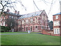
Former College buildings, Ripon
Part of the former College of Ripon and York St John, which was a teacher training college for many years. The building has now been converted to apartments. This wing looks suspiciously like a former chapel. 2017 update: I am informed by an ex student that this wing contained a library on the upper floor and the geography department downstairs.
Image: © Gordon Hatton
Taken: 30 Dec 2007
0.08 miles
10
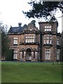
Highfield House
Victorian gentlemans residence in the grounds of the former Ripon College, now offices for NYCC Education dept. The house is right on the grid line of two squares [according to the 1:25000 map], but the front and the photo position are both in SE3071.
Image: © Gordon Hatton
Taken: 30 Dec 2007
0.11 miles