IMAGES TAKEN NEAR TO
Heathfield, HARROGATE, HG3 5PU
Introduction
This page details the photographs taken nearby to Heathfield, HG3 5PU by members of the Geograph project.
The Geograph project started in 2005 with the aim of publishing, organising and preserving representative images for every square kilometre of Great Britain, Ireland and the Isle of Man.

There are currently over 7.5m images from over14,400 individuals and you can help contribute to the project by visiting https://www.geograph.org.uk
Image Map
Images are licensed for reuse under creativecommons.org/licenses/by-sa/2.0
Notes
- Clicking on the map will re-center to the selected point.
- The higher the marker number, the further away the image location is from the centre of the postcode.
Image Listing (16 Images Found)
Images are licensed for reuse under creativecommons.org/licenses/by-sa/2.0
Image
Details
Distance
1
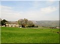
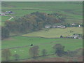
Over field at Heathfield
The house is on Grange Lane and to its right is the tin chapel, still in use?
Image: © Martin Dawes
Taken: 7 May 2016
0.02 miles
2
Tin chapel, Heathfield
A marginally different angle from the views in http://www.geograph.org.uk/search.php?i=22821633, taken from the same spot as Image
Image: © Derek Harper
Taken: 27 Jun 2011
0.03 miles
3
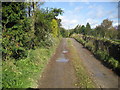
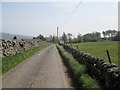
Nidderdale Way at Heathfield
The Long Distance Footpath at Heathfield approaching the Tin Chapel.
Image: © Chris Heaton
Taken: 22 Oct 2008
0.04 miles
4
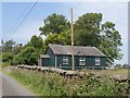
'Tin' chapel, Heathfield
Since Bob Danylec's photo of April 2006 this little building has had a lick of paint and a new front door. A wooden cross has also appeared on the gable top, so is it back in use? One must come to the conclusion that it is still not used as a chapel as there are no signs or notices to suggest that it is.
Image: © Gordon Hatton
Taken: 23 Sep 2008
0.04 miles
5
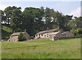
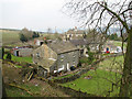
Buildings at Heathfield
Seen from Grange Lane. To the right is Leng House, the Leeds Battalion Hostel of the Boys Brigade. The Nidderdale Way runs behind it and the cottages to its left, and up through the trees.
Image: © Derek Harper
Taken: 27 Jun 2011
0.05 miles
6
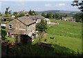
Heathfield
A similar view to Image, but with leaves on the trees. The buildings in the foreground are those shown in Image from just down the road to the right of The Grange (right, http://www.britishlistedbuildings.co.uk/en-331375-heathfield-grange-stonebeck-down ).
Image: © Derek Harper
Taken: 27 Jun 2011
0.07 miles
7
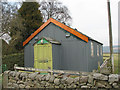
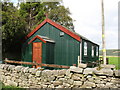
The Ex-Wesleyan Chapel, Heathfield.
Ceased to be used as a chapel in 1970.
Image: © Bob Danylec
Taken: 15 Apr 2006
0.07 miles
10
Heathfield.
Heathfield as approached from the Nidderdale Way.
Image: © Bob Danylec
Taken: 15 Apr 2006
0.10 miles