IMAGES TAKEN NEAR TO
Springfield Close, HARROGATE, HG3 5PB
Introduction
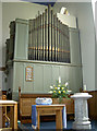
This page details the photographs taken nearby to Springfield Close, HG3 5PB by members of the Geograph project.
The Geograph project started in 2005 with the aim of publishing, organising and preserving representative images for every square kilometre of Great Britain, Ireland and the Isle of Man.

There are currently over 7.5m images from over14,400 individuals and you can help contribute to the project by visiting https://www.geograph.org.uk
Image Map (Loading...)


Getting Data...Please wait
Leaflet Map data © OpenStreetMap
Images are licensed for reuse under creativecommons.org/licenses/by-sa/2.0
Notes
- Clicking on the map will re-center to the selected point.
- The higher the marker number, the further away the image location is from the centre of the postcode.
Image Listing (243 Images Found)
Images are licensed for reuse under creativecommons.org/licenses/by-sa/2.0
Image
Details
Distance
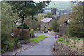
1
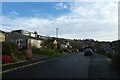
Along Bishop Garth
Looking along Bishop Garth near the junction with Bishop Way.
Image: © DS Pugh
Taken: 1 Jan 2023
0.06 miles
2

Stained glass of St Cuthbert's
This fine church is almost opposite the Nidderdale Museum, at the top of the village.
Image: © Neil Owen
Taken: 23 Jul 2010
0.07 miles
3
Old and new
St Cuthbert's church in Pateley Bridge keeps up with the times when it comes to music.
Image: © Neil Owen
Taken: 23 Jul 2010
0.07 miles
4
![Parish church [2]](https://s0.geograph.org.uk/geophotos/07/03/18/7031824_05875930_120x120.jpg)
Parish church [2]
Part of the churchyard.
The Anglican parish church of St Cuthbert was built in 1827 to replace the former parish church of St Mary, the ruins of which are still extant in Old Church Lane. Constructed of ashlar under a slate roof. Listed, grade II, with details at: https://historicengland.org.uk/listing/the-list/list-entry/1315300
Pateley Bridge is a small market town, the market charter being granted in 1320. Located on the banks of the River Nidd, the town is some 11 miles northwest of Harrogate, some 10 miles southwest of Ripon and is within the Nidderdale Area of Outstanding Natural Beauty. The town is popular with tourists exploring the Yorkshire Dales.
Image: © Michael Dibb
Taken: 23 Jun 2021
0.07 miles
5

Church of St Cuthbert, Pateley Bridge
The interior of the church looking east. The current layout has the altar brought forward to the congregation rather than being in the rather restricted original sanctuary.
Image: © Alan Murray-Rust
Taken: 9 Sep 2017
0.07 miles
6
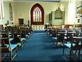
St Cuthbert's, Pateley Bridge - nave
The nave has been reordered with carpet over the floor. The chairs, though, are not in a contemporary style and may have been introduced earlier in the church's history. See also Image
Image: © Stephen Craven
Taken: 7 May 2018
0.07 miles
7
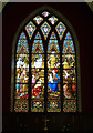
St Cuthbert's, Pateley Bridge - east window
The window depicts the Adoration of the Magi. It dates from 1893, at which time bells were also introduced to the tower, and is the work of F Comere & J Capronnier of Brussels.
Image: © Stephen Craven
Taken: 7 May 2018
0.07 miles
8
![Parish church [3]](https://s1.geograph.org.uk/geophotos/07/03/18/7031825_94179fd4_120x120.jpg)
Parish church [3]
The fine east window.
The Anglican parish church of St Cuthbert was built in 1827 to replace the former parish church of St Mary, the ruins of which are still extant in Old Church Lane. Constructed of ashlar under a slate roof. Listed, grade II, with details at: https://historicengland.org.uk/listing/the-list/list-entry/1315300
Pateley Bridge is a small market town, the market charter being granted in 1320. Located on the banks of the River Nidd, the town is some 11 miles northwest of Harrogate, some 10 miles southwest of Ripon and is within the Nidderdale Area of Outstanding Natural Beauty. The town is popular with tourists exploring the Yorkshire Dales.
Image: © Michael Dibb
Taken: 23 Jun 2021
0.07 miles
9
![Parish church [4]](https://s3.geograph.org.uk/geophotos/07/03/18/7031827_4c32ab9a_120x120.jpg)
Parish church [4]
This bell, probably from Fountains Abbey, formerly hung in the old parish church of St Mary. It was moved to St Cuthbert's in 1827 and hung until 1893 when a peal of bells was donated and this bell was given to the donors. Now returned to the church as a memorial to the son of the donors who died in WWI.
The Anglican parish church of St Cuthbert was built in 1827 to replace the former parish church of St Mary, the ruins of which are still extant in Old Church Lane. Constructed of ashlar under a slate roof. Listed, grade II, with details at: https://historicengland.org.uk/listing/the-list/list-entry/1315300
Pateley Bridge is a small market town, the market charter being granted in 1320. Located on the banks of the River Nidd, the town is some 11 miles northwest of Harrogate, some 10 miles southwest of Ripon and is within the Nidderdale Area of Outstanding Natural Beauty. The town is popular with tourists exploring the Yorkshire Dales.
Image: © Michael Dibb
Taken: 23 Jun 2021
0.07 miles
10
Old Church Lane, Pateley Bridge
Entering the town down a steep hill. The lane is named after St Mary's Church back up the hill which is now in disuse but maintained as a ruin.
Image: © Bill Boaden
Taken: 16 Apr 2011
0.07 miles