IMAGES TAKEN NEAR TO
High Crest, HARROGATE, HG3 5NU
Introduction
This page details the photographs taken nearby to High Crest, HG3 5NU by members of the Geograph project.
The Geograph project started in 2005 with the aim of publishing, organising and preserving representative images for every square kilometre of Great Britain, Ireland and the Isle of Man.

There are currently over 7.5m images from over14,400 individuals and you can help contribute to the project by visiting https://www.geograph.org.uk
Image Map (Loading...)


Getting Data...Please wait
Leaflet Map data © OpenStreetMap
Images are licensed for reuse under creativecommons.org/licenses/by-sa/2.0
Notes
- Clicking on the map will re-center to the selected point.
- The higher the marker number, the further away the image location is from the centre of the postcode.
Image Listing (332 Images Found)
Images are licensed for reuse under creativecommons.org/licenses/by-sa/2.0
Image
Details
Distance
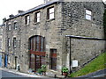
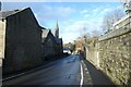
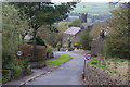
2
Pateley Bridge
View of Pateley Bridge from Old Church Lane.
Image: © David Rogers
Taken: 2 Apr 2009
0.06 miles
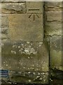
3
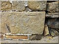
Pateley Bridge, Church Lane cottage
The benchmark is cut into the road facing wall of the cottage, and is cut into a right cornerstone.
Image: © Mel Towler
Taken: 11 Sep 2022
0.06 miles
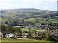
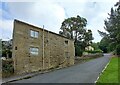
4
Field below the Church
Looking across a field from a footpath climbing up to Church.
Image: © DS Pugh
Taken: 1 Jan 2023
0.07 miles
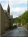
5
Pateley Bridge Methodists Church
Looking along Ripon Road in Pateley Bridge.
Image: © DS Pugh
Taken: 1 Jan 2023
0.07 miles
6
Pateley Bridge, Church Lane cottage
There is a benchmark cut into the road facing wall of the cottage, and it is cut into a right cornerstone.
Image: © Mel Towler
Taken: 11 Sep 2022
0.07 miles
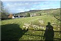
7
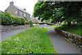
Old Church Lane, Pateley Bridge
Footpath beside Old Church Lane in Pateley Bridge.
Image: © Philip Halling
Taken: 10 Jun 2013
0.07 miles
8
Bench mark, Pateley Bridge Methodist Church
See http://www.geograph.org.uk/photo/5536644 for location.
Image: © Alan Murray-Rust
Taken: 9 Sep 2017
0.07 miles
9
Old Church Lane, Pateley Bridge
Entering the town down a steep hill. The lane is named after St Mary's Church back up the hill which is now in disuse but maintained as a ruin.
Image: © Bill Boaden
Taken: 16 Apr 2011
0.07 miles
10
Spire and tower, Pateley Bridge
Methodist (left) and Anglican churches, on Ripon Road.
Image: © Alan Murray-Rust
Taken: 9 Sep 2017
0.07 miles