IMAGES TAKEN NEAR TO
Fellbeck, HARROGATE, HG3 5EQ
Introduction
This page details the photographs taken nearby to HG3 5EQ by members of the Geograph project.
The Geograph project started in 2005 with the aim of publishing, organising and preserving representative images for every square kilometre of Great Britain, Ireland and the Isle of Man.

There are currently over 7.5m images from over14,400 individuals and you can help contribute to the project by visiting https://www.geograph.org.uk
Image Map (Loading...)


Getting Data...Please wait
Leaflet Map data © OpenStreetMap
Images are licensed for reuse under creativecommons.org/licenses/by-sa/2.0
Notes
- Clicking on the map will re-center to the selected point.
- The higher the marker number, the further away the image location is from the centre of the postcode.
Image Listing (37 Images Found)
Images are licensed for reuse under creativecommons.org/licenses/by-sa/2.0
Image
Details
Distance
3
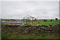
Diversification into Llama Trekking in Nidderdale
A bit further along the Nidderdale Way we encountered the llamas.
Image: © Jonathan Long
Taken: 20 Aug 2020
0.08 miles
4
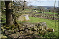
Exposed rocks by the Nidderdale Way
There are several parallel dry stone walls running down into Nidderdale. These rocks interrupt the farmland. On the skyline, and partly behind the trees, are Brimham Rocks with much more dramatic rocks.
Image: © Bill Boaden
Taken: 6 May 2013
0.10 miles
6
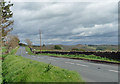
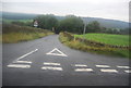
Country road near Wilsill (1)
The B6265 heading east and leading eventually to Ripon.
Image: © Stephen Richards
Taken: 15 May 2013
0.11 miles
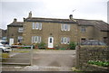
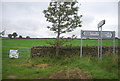
8

Wilsill, The Raikes
According to the OS benchmark database there is a benchmark cut into the roadside wall on the inner bend of a hairpin. Part of the wall has been demolished with several stones in and around the verge. Nothing was found.
Image: © Mel Towler
Taken: 6 Aug 2022
0.11 miles
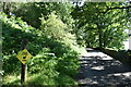
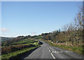
9
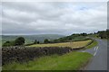
B6265 junction for Wilsill
Typical stone walls around the fields. Wilsill lies in the valley to the left
Image: © David Smith
Taken: 18 Jun 2015
0.11 miles