IMAGES TAKEN NEAR TO
Wilsill, HARROGATE, HG3 5EA
Introduction
This page details the photographs taken nearby to HG3 5EA by members of the Geograph project.
The Geograph project started in 2005 with the aim of publishing, organising and preserving representative images for every square kilometre of Great Britain, Ireland and the Isle of Man.

There are currently over 7.5m images from over14,400 individuals and you can help contribute to the project by visiting https://www.geograph.org.uk
Image Map
Images are licensed for reuse under creativecommons.org/licenses/by-sa/2.0
Notes
- Clicking on the map will re-center to the selected point.
- The higher the marker number, the further away the image location is from the centre of the postcode.
Image Listing (46 Images Found)
Images are licensed for reuse under creativecommons.org/licenses/by-sa/2.0
Image
Details
Distance
2

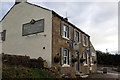
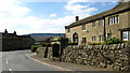
Wilsill, Byril House
The benchmark is cut into the north face wall of the house, which is located on the south side of B6165.
Image: © Mel Towler
Taken: 6 Aug 2022
0.02 miles
3

Wilsill, Byril House
There is a benchmark cut into the north facing wall of the house, which is located on the south side of B6165.
Image: © Mel Towler
Taken: 6 Aug 2022
0.02 miles
4
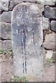
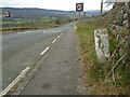
Old Milestone, on the B6165, Wilsill, The Raikes
Located on the North side of road, on narrow verge, nr bend. Carved stone post, 18th century. Alternative view see http://www.geograph.org.uk/photo/1246812
Inscription reads: LBP(in N shaped top) / Survey / 1741
Milestone Society National ID: YN_KBPB13
Image: © Christine Minto
Taken: 31 Dec 2005
0.02 miles
6
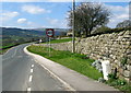
Wilsill Milestone
On the roadside between Wilsill and Glasshouses, The front face refers to a survey of 1741, while the far side shows Knaresboro 13 miles and the near side Pateley Bridge 1 1/2 miles.
Image: © David Rogers
Taken: 2 Apr 2009
0.08 miles
7
Old milestone
A view at Wilsill along the B6165 towards Pateley Bridge showing the right face of the old stone. An old photograph showed PATELEY/BRIDGE/1 so that was painted on when the stone was repainted several years ago by a Milestone Society member.
Image: © Chris Minto
Taken: 12 Feb 2023
0.09 miles
8
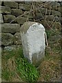
Old milestone
This stone is at Wilsill at The Raikes junction. The left face had KNARES/BORO/13 inscribed and painted on in 2004 by a Milestone Society member after reference to an old photo dated 2001. The front face has LBP in the n-shaped top and Survey/1741 below.
Image: © Chris Minto
Taken: 12 Feb 2023
0.09 miles
9

Wilsill Bridge
According to the OS benchmark database there is a rivet benchmark cut into the southern parapet and on the north face of the bridge. There is no room for a search because of traffic and minimal manoeuvring space. It is unknown if the benchmark still remains.
Image: © Mel Towler
Taken: 17 Feb 2023
0.11 miles
10
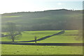
Wilsill Trough
On The Raikes and dated 1882.
Image: © David Rogers
Taken: 2 Apr 2009
0.11 miles