IMAGES TAKEN NEAR TO
Summerbridge, HARROGATE, HG3 4JG
Introduction
This page details the photographs taken nearby to HG3 4JG by members of the Geograph project.
The Geograph project started in 2005 with the aim of publishing, organising and preserving representative images for every square kilometre of Great Britain, Ireland and the Isle of Man.

There are currently over 7.5m images from over14,400 individuals and you can help contribute to the project by visiting https://www.geograph.org.uk
Image Map (Loading...)


Getting Data...Please wait
Leaflet Map data © OpenStreetMap
Images are licensed for reuse under creativecommons.org/licenses/by-sa/2.0
Notes
- Clicking on the map will re-center to the selected point.
- The higher the marker number, the further away the image location is from the centre of the postcode.
Image Listing (80 Images Found)
Images are licensed for reuse under creativecommons.org/licenses/by-sa/2.0
Image
Details
Distance
1
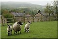
Ewe and lambs, Summerbridge
Guise Cliffs and Abraham Crags are on the skyline (honest!).
Image: © Katy Walters
Taken: 17 May 2007
0.03 miles
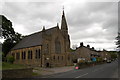
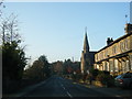
3
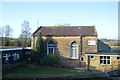
Summerbridge Methodist Church and war memorial
Image: © David Martin
Taken: 21 Jun 2013
0.09 miles
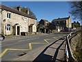
5
B6165 at Summerbridge
The house on the right can be seen on the left of Image; on the left is the junction with Foundry Lane, which runs down to the Nidd near the weir.
Image: © Derek Harper
Taken: 5 Apr 2012
0.11 miles
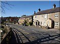
6
B6165 at Summerbridge
From the junction with Foundry Lane, looking up the hill towards the village centre. House on the left currently available at £285000.
Image: © Derek Harper
Taken: 5 Apr 2012
0.11 miles
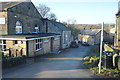
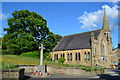
8
B6165 nears Summerbridge Methodist Church
Image: © Colin Pyle
Taken: 1 Nov 2015
0.12 miles
10
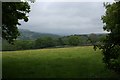
Nidderdale, near Old Spring Wood
Looking up the valley towards Pateley Bridge.
Image: © Katy Walters
Taken: 16 May 2007
0.12 miles