IMAGES TAKEN NEAR TO
Summerbridge, HARROGATE, HG3 4JF
Introduction
This page details the photographs taken nearby to HG3 4JF by members of the Geograph project.
The Geograph project started in 2005 with the aim of publishing, organising and preserving representative images for every square kilometre of Great Britain, Ireland and the Isle of Man.

There are currently over 7.5m images from over14,400 individuals and you can help contribute to the project by visiting https://www.geograph.org.uk
Image Map
Images are licensed for reuse under creativecommons.org/licenses/by-sa/2.0
Notes
- Clicking on the map will re-center to the selected point.
- The higher the marker number, the further away the image location is from the centre of the postcode.
Image Listing (114 Images Found)
Images are licensed for reuse under creativecommons.org/licenses/by-sa/2.0
Image
Details
Distance
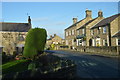
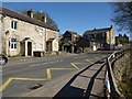
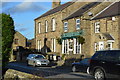
1
B6165 at Summerbridge
The house on the right can be seen on the left of Image; on the left is the junction with Foundry Lane, which runs down to the Nidd near the weir.
Image: © Derek Harper
Taken: 5 Apr 2012
0.01 miles
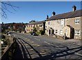
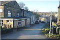
2
B6165 at Summerbridge
From the junction with Foundry Lane, looking up the hill towards the village centre. House on the left currently available at £285000.
Image: © Derek Harper
Taken: 5 Apr 2012
0.01 miles
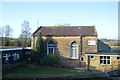
7
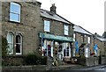
Summerbridge Store
Classic village shop. Just the place to buy some Os or fork handles.
Image: © Alan Murray-Rust
Taken: 13 Sep 2017
0.08 miles