IMAGES TAKEN NEAR TO
Hill Top View, HARROGATE, HG3 4BH
Introduction
This page details the photographs taken nearby to Hill Top View, HG3 4BH by members of the Geograph project.
The Geograph project started in 2005 with the aim of publishing, organising and preserving representative images for every square kilometre of Great Britain, Ireland and the Isle of Man.

There are currently over 7.5m images from over14,400 individuals and you can help contribute to the project by visiting https://www.geograph.org.uk
Image Map (Loading...)


Getting Data...Please wait
Leaflet Map data © OpenStreetMap
Images are licensed for reuse under creativecommons.org/licenses/by-sa/2.0
Notes
- Clicking on the map will re-center to the selected point.
- The higher the marker number, the further away the image location is from the centre of the postcode.
Image Listing (33 Images Found)
Images are licensed for reuse under creativecommons.org/licenses/by-sa/2.0
Image
Details
Distance
2
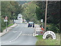
Dacre: approaching site of former station, 1995
View NNE, towards Summerbridge on B6451. The station had been near the bend ahead, beyond the entrance to the goods yard nearer on the left. It was on the ex-NER Harrogate - Pateley Bridge branch, which was closed to passengers 7/4/51, to goods 31/10/64. (See Image]).
Image: © Ben Brooksbank
Taken: 28 Apr 1995
0.04 miles
3
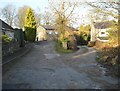
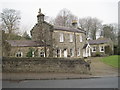
School Lane, Dacre Banks
Lane leading to the old youth hostel at Dacre Banks, now sadly closed for many years
Image: © Chris Heaton
Taken: 27 Mar 2012
0.05 miles
5
Dacre railway station site, Yorkshire
Opened in 1862 by the North Eastern Railway on its line from Harrogate to Pateley Bridge, this station closed to passengers in 1950. Forecourt.
Image: © Nigel Thompson
Taken: 23 Feb 2013
0.09 miles
6
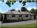
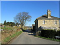
Dacre Banks village hall
The village hall looks out over a small triangular green near the centre of the village.
Image: © Gordon Hatton
Taken: 17 Jun 2007
0.10 miles
7
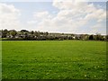
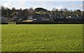
Over fields to the village Dacre Banks
The village of Dacre is to the left up the B6451 which runs through Dacre Banks
Image: © Martin Dawes
Taken: 5 May 2016
0.12 miles
8
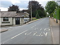
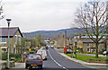
Road (B6451) passing through Dacre Banks
Looking southward with Dacre and Hartwith Village Hall on the left of the picture.
Image: © Peter Wood
Taken: 31 Jul 2017
0.12 miles
10
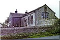
Former Dacre Banks Youth Hostel, 1982
In 1982 this was a simple grade non-VAT Youth Hostel (£1.85 per night for those aged 21 and over, sleeping in dormitories) described in the YHA Handbook as "A former school building in Nidderdale, one of the smaller and quieter of the Yorkshire Dales. The oldest hostel in the region".
Sadly it must have been one of the smaller and quieter youth hostels too, as it closed in 1987.
Image: © Nigel Thompson
Taken: 7 Sep 1982
0.14 miles