IMAGES TAKEN NEAR TO
Summerbridge, HARROGATE, HG3 4AU
Introduction
This page details the photographs taken nearby to HG3 4AU by members of the Geograph project.
The Geograph project started in 2005 with the aim of publishing, organising and preserving representative images for every square kilometre of Great Britain, Ireland and the Isle of Man.

There are currently over 7.5m images from over14,400 individuals and you can help contribute to the project by visiting https://www.geograph.org.uk
Image Map
Images are licensed for reuse under creativecommons.org/licenses/by-sa/2.0
Notes
- Clicking on the map will re-center to the selected point.
- The higher the marker number, the further away the image location is from the centre of the postcode.
Image Listing (12 Images Found)
Images are licensed for reuse under creativecommons.org/licenses/by-sa/2.0
Image
Details
Distance
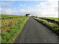
2
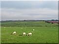
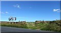
Tracks and Footpath to Padside Hall
Looking south-eastward.
Image: © Peter Wood
Taken: 25 Dec 2019
0.14 miles
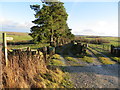
3
Braithwaite Lane approaching Sandy Gate
Looking south-westward.
Image: © Peter Wood
Taken: 25 Dec 2019
0.14 miles
5
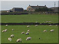
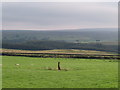
Sunny spot on a misty day
The small amount of shelter afforded by Heyshaw Moor to the north was just enough to break up the scudding low cloud and mist blowing in from the North Sea, thus making this sheep pasture a sunny spot.
Image: © Gordon Hatton
Taken: 14 Aug 2020
0.16 miles
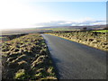
6
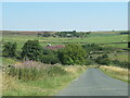
Fall Lane
The road drops gently towards Fall Bridge over a minor beck. Burns Farm is in the distance.
Image: © Gordon Hatton
Taken: 12 Aug 2022
0.16 miles
7
Mystery stone in a field
A single stone around 1.5m high in the middle of a pasture close by the junction of Fall Lane and Sandy Gate Road. It isn't a boundary stone, but examination of 19thC maps shows an extra field boundary here [now gone] and I assume that this was once a gatepost. The view is towards the wooded flanks of the Washburn valley above Thruscross Reservoir.
Image: © Gordon Hatton
Taken: 14 Aug 2020
0.19 miles
8
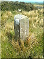
Old Boundary Marker
Knaresborough Forest Enclosure Boundary Marker in a field on the west side of Padside Beck, 250 metres north of Padside Hall. On the boundary of Dacre and Thornthwaite with Padside parishes. Inscribed 29 / K · F / 1767. Erected to delineate the Forest of Knaresborough preparatory to enclosure.
Milestone Society National ID: YW_KF29pb
Image: © D Garside
Taken: 3 May 2013
0.21 miles
9
West End, junction opposite Hoodstorth Lane
A wider angle showing the double gatehole on the east side of Sandy Gate, and directly opposite Hoodstorth Lane junction. The bench mark is cut into the left gatepost of the right gatehole.
Image: © Mel Towler
Taken: 20 Sep 2021
0.21 miles
10
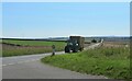
Delivery of straw bales
The second of two tractors pulling loads of straw bales along the road towards Greenhow Hill. They must have travelled some distance from arable farms down in the vale, and are presumably heading towards one of the hill farms with bedding for animals. This long straight road has a variety of names, including Greenhow Hill Road, Redlish Road, Sandy Gate and Duck Street, but I note that the OS map also includes Blake Gate, which is not a name I'm familiar with.
Image: © Gordon Hatton
Taken: 12 Aug 2022
0.21 miles