IMAGES TAKEN NEAR TO
Hincks Hall Lane, HG3 3PN
Introduction
This page details the photographs taken nearby to Hincks Hall Lane, HG3 3PN by members of the Geograph project.
The Geograph project started in 2005 with the aim of publishing, organising and preserving representative images for every square kilometre of Great Britain, Ireland and the Isle of Man.

There are currently over 7.5m images from over14,400 individuals and you can help contribute to the project by visiting https://www.geograph.org.uk
Image Map
Images are licensed for reuse under creativecommons.org/licenses/by-sa/2.0
Notes
- Clicking on the map will re-center to the selected point.
- The higher the marker number, the further away the image location is from the centre of the postcode.
Image Listing (59 Images Found)
Images are licensed for reuse under creativecommons.org/licenses/by-sa/2.0
Image
Details
Distance
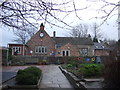
1
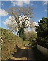
Kingswood Lane, Markington
The Ripon Rowel Walk setting off from the village along bridleway 15 86/12/2. The ivy-clad tree looks like an ash.
Image: © Derek Harper
Taken: 19 Apr 2014
0.07 miles
2
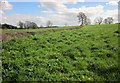
Fields near Markington
From a gateway beside the (ash?) tree shown in Image], looking to the right.
Image: © Derek Harper
Taken: 19 Apr 2014
0.07 miles
3
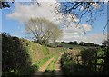
Ripon Rowel Walk near Markington
From the same spot as Image], following bridleway 15 86/12/2 along Kingswood Lane.
Image: © Derek Harper
Taken: 19 Apr 2014
0.09 miles
4
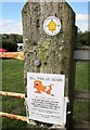
No dog phoo
"Please do not allow your dog to phoo in the caravan park". I understand what they mean, but this spelling was a new one on me. This is by the Ripon Rowel Walk and the waymark indicates footpath 15 86/14/1, hence the concern.
Image: © Derek Harper
Taken: 19 Apr 2014
0.11 miles
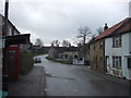
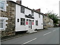
7
Markington, Yorkshire Hussar PH
There is a benchmark on the 2nd course of stone on the extreme right of the pub, on the wall facing the road.
Image: © Mel Towler
Taken: 24 Oct 2021
0.13 miles
8
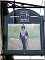
Sign for the Yorkshire Hussar
The Yorkshire Hussars was a unit of the British Army from 1794–1956.
First formed as volunteer cavalry regiment in 1794 during the French Revolutionary Wars. It was converted to an armoured role during World War Two. In 1956 it merged with two other Yorkshire regiments to form the Queen's Own Yorkshire Yeomanry.
Image: © Maigheach-gheal
Taken: 6 Oct 2010
0.13 miles
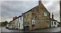
9
The Yorkshire Hussar, Markington
The inn has a caravan park attached. For a close-up of the sign Image
Image: © Maigheach-gheal
Taken: 6 Oct 2010
0.13 miles
10
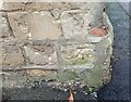
Markington, Yorkshire Hussar PH
The benchmark on the 2nd course of stone is on the extreme right of the pub, on the wall facing the road.
Image: © Mel Towler
Taken: 24 Oct 2021
0.13 miles