IMAGES TAKEN NEAR TO
Broomfield, HARROGATE, HG3 3AF
Introduction
This page details the photographs taken nearby to Broomfield, HG3 3AF by members of the Geograph project.
The Geograph project started in 2005 with the aim of publishing, organising and preserving representative images for every square kilometre of Great Britain, Ireland and the Isle of Man.

There are currently over 7.5m images from over14,400 individuals and you can help contribute to the project by visiting https://www.geograph.org.uk
Image Map
Images are licensed for reuse under creativecommons.org/licenses/by-sa/2.0
Notes
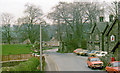
- Clicking on the map will re-center to the selected point.
- The higher the marker number, the further away the image location is from the centre of the postcode.
Image Listing (56 Images Found)
Images are licensed for reuse under creativecommons.org/licenses/by-sa/2.0
Image
Details
Distance
3
Site of Birstwith station, 1976
View SW, across course of railway: NER Nidd Valley branch, Harrogate (to left) - Pately Bridge (to right), closed to passengers 2/4/51, goods 31/10/64; the station was on the right.
Image: © Ben Brooksbank
Taken: 19 Apr 1976
0.04 miles
5
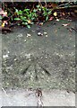
Birstwith, old railway bridge buttress
The rivet benchmark is cut into the disused bridge buttress on the east side of Wreaks Road.
Image: © Mel Towler
Taken: 21 Nov 2022
0.05 miles
6
Birstwith, old railway bridge buttress
There is a rivet benchmark cut into the disused bridge buttress on the east side of Wreaks Road.
Image: © Mel Towler
Taken: 21 Nov 2022
0.06 miles
7
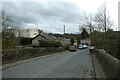
Wreaks Road
Looking along Wreaks Road from the bridge in Birstwith.
Image: © DS Pugh
Taken: 28 Mar 2021
0.07 miles
8
Birtstwith, Wreaks Bridge
According to the OS benchmark database there is a rivet benchmark cut into the south-east parapet. The area is directly behind the road sign which is thick in tough, evergreen vegetation. Nothing was found.
Image: © Mel Towler
Taken: 21 Nov 2022
0.07 miles
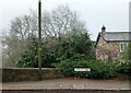
9
The Old Station Inn, Birstwith
Half hidden by trees; view from Wreaks Bridge of the Inn also known as The Station Hotel.
Image: © David Rogers
Taken: 20 Sep 2010
0.07 miles
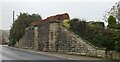
10

Birstwith railway station (site), Yorkshire
Opened in 1862 by the North Eastern Railway on its line from Harrogate to Pateley Bridge, the station is believed to have been situated on the now removed embankment roughly where the house now stands. It closed to passengers in 1950. The bridge abutment is one of the few reminders of a railway ever having been here.
Image: © Nigel Thompson
Taken: 23 Feb 2013
0.07 miles