IMAGES TAKEN NEAR TO
Stumps Lane, HARROGATE, HG3 2RR
Introduction
This page details the photographs taken nearby to Stumps Lane, HG3 2RR by members of the Geograph project.
The Geograph project started in 2005 with the aim of publishing, organising and preserving representative images for every square kilometre of Great Britain, Ireland and the Isle of Man.

There are currently over 7.5m images from over14,400 individuals and you can help contribute to the project by visiting https://www.geograph.org.uk
Image Map
Images are licensed for reuse under creativecommons.org/licenses/by-sa/2.0
Notes
- Clicking on the map will re-center to the selected point.
- The higher the marker number, the further away the image location is from the centre of the postcode.
Image Listing (12 Images Found)
Images are licensed for reuse under creativecommons.org/licenses/by-sa/2.0
Image
Details
Distance
1
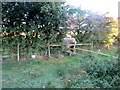
Cattle at Stile
Public footpath 15.91/23/3 near Turner Ing.
Image: © Peter Holmes
Taken: 2 Oct 2016
0.03 miles
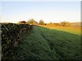
2
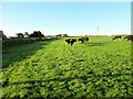
Cattle in field
Public footpath 15.91/23/3 to Dicken Dyke Farm.
Image: © Peter Holmes
Taken: 2 Oct 2016
0.06 miles
3
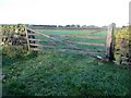
Gate on path to Stumps Lane
Apparent route of public footpath 15.91/24/1; differs from right of way path shown on OS map.
Image: © Peter Holmes
Taken: 2 Oct 2016
0.07 miles
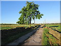
4
Track to Highland Croft and Turner Ing Farm
Image: © Mark Anderson
Taken: 26 May 2018
0.09 miles
5
Footpath to Stumps Lane
Public footpath 15.91/24/1 with early morning dew.
Image: © Peter Holmes
Taken: 2 Oct 2016
0.10 miles
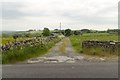
6
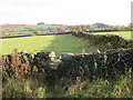
A peculiar path
The OS map shows this path along the south side of the wall seen on the right, but the stile is on the north side. The same is shown on NYCC's footpath map, so one wonders what the exact line should be. There is no roadside signpost either. On this occasion the field beyond the stile was a wet morass, made worse by cattle churning up the surface.
Image: © Gordon Hatton
Taken: 13 Nov 2019
0.12 miles
7
Lone Tree Heck Gill Lane
Lane leading to Heck Gill Farm and public bridleway 15.91/25/1.
Image: © Peter Holmes
Taken: 2 Oct 2016
0.17 miles
8
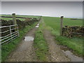
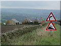
Gateway to Pastures off Stumps Lane
Wet pastures above Nidderdale just off the lane running down from Menwith Hill to Darley.
Image: © Chris Heaton
Taken: 23 Apr 2012
0.19 miles
9
Old Farm - New House
One of the many refurbished old farm houses.
Image: © Malcolm Street
Taken: 13 Oct 2005
0.20 miles
10
Darley, Stumps House
The benchmark is cut into the gable end of the farmhouse, which is on the east side of Stumps Lane.
Image: © Mel Towler
Taken: 26 Aug 2022
0.21 miles