IMAGES TAKEN NEAR TO
Menwith Hill, HARROGATE, HG3 2RN
Introduction
This page details the photographs taken nearby to HG3 2RN by members of the Geograph project.
The Geograph project started in 2005 with the aim of publishing, organising and preserving representative images for every square kilometre of Great Britain, Ireland and the Isle of Man.

There are currently over 7.5m images from over14,400 individuals and you can help contribute to the project by visiting https://www.geograph.org.uk
Image Map
Images are licensed for reuse under creativecommons.org/licenses/by-sa/2.0
Notes
- Clicking on the map will re-center to the selected point.
- The higher the marker number, the further away the image location is from the centre of the postcode.
Image Listing (7 Images Found)
Images are licensed for reuse under creativecommons.org/licenses/by-sa/2.0
Image
Details
Distance
1
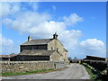
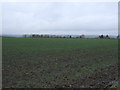
Prospect Farm, Menwith Hill
Farming operation by the B6451 Otley/Summerbridge Road between Darley and the Menwith Hill "Golfballs."
Image: © Chris Heaton
Taken: 17 Apr 2012
0.00 miles
4
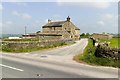
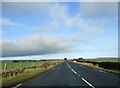
Welcome to Nidderdale
Hardgroves Hill (B6451) looking north.
Image: © JThomas
Taken: 10 Dec 2016
0.10 miles
6
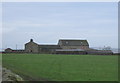
The plateau toward Nidderdale
Wharfedale is behind and Nidderdale ahead. Prospect Farm on the right ahead
Image: © Martin Dawes
Taken: 15 Jan 2023
0.15 miles
7
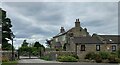
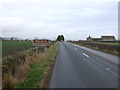
Darley, Milner Mount
According to the OS benchmark database there is a cutmark on the left edge of the gable end of the large house seen in the background. The house is gated and inaccessible.
Image: © Mel Towler
Taken: 26 Aug 2022
0.25 miles