IMAGES TAKEN NEAR TO
Darley, HARROGATE, HG3 2QB
Introduction
This page details the photographs taken nearby to HG3 2QB by members of the Geograph project.
The Geograph project started in 2005 with the aim of publishing, organising and preserving representative images for every square kilometre of Great Britain, Ireland and the Isle of Man.

There are currently over 7.5m images from over14,400 individuals and you can help contribute to the project by visiting https://www.geograph.org.uk
Image Map (Loading...)


Getting Data...Please wait
Leaflet Map data © OpenStreetMap
Images are licensed for reuse under creativecommons.org/licenses/by-sa/2.0
Notes
- Clicking on the map will re-center to the selected point.
- The higher the marker number, the further away the image location is from the centre of the postcode.
Image Listing (40 Images Found)
Images are licensed for reuse under creativecommons.org/licenses/by-sa/2.0
Image
Details
Distance
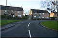
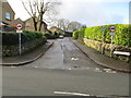
3
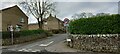
Darley, junction of Main Street and Sheepcote Lane
There is a benchmark cut into the first course of stone and is to the right of the street name.
Image: © Mel Towler
Taken: 7 Mar 2022
0.07 miles
4
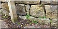
Darley, junction of Main Street and Sheepcote Lane
The benchmark is cut into the first course of stone and is to the right of the street name.
Image: © Mel Towler
Taken: 7 Mar 2022
0.07 miles
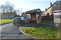
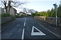
5
Sheepcote Lane leaving Main Street in Darley
Looking south-westward.
Image: © Peter Wood
Taken: 25 Dec 2019
0.08 miles
7
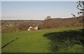
View near Darley
From Station Road just below the built-up area of Darley, looking down the Nidd valley, with one of the houses on Niddside. On the left, across the river, are a cluster of buildings around White Oak and Birchfield Farms.
Image: © Derek Harper
Taken: 5 Apr 2012
0.10 miles
8
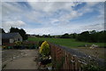
Nidderdale - looking West from Southfield Farm
Looking up Nidderdale from the rear of Southfield farm.
Image: © John Webb
Taken: 6 Jun 2011
0.13 miles
9
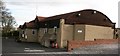
Darley Memorial Hall
A village hall with an unusual history. The building [minus its modern stone cladding] was once part of the temporary village that existed at the head of Nidderdale during the construction of Scar House and Angram reservoirs.
It served as the Canteen at the temporary village. It was re-erected in Darley and opened in November 1947 as a memorial to those killed in WW2. (Information found in "Darley Remembered" compiled by Sue Welch, published 2009 by Darley in Bloom, ISBN 978 0 9563280 0 9)
Image: © Gordon Hatton
Taken: 4 Feb 2008
0.13 miles
10
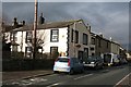
Darley post office and stores
Centrally situated in this long street village in lower Nidderdale.
Image: © Gordon Hatton
Taken: 4 Feb 2008
0.14 miles