IMAGES TAKEN NEAR TO
Queen Ethelburgas Park, HARROGATE, HG3 2GE
Introduction
This page details the photographs taken nearby to Queen Ethelburgas Park, HG3 2GE by members of the Geograph project.
The Geograph project started in 2005 with the aim of publishing, organising and preserving representative images for every square kilometre of Great Britain, Ireland and the Isle of Man.

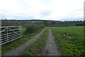
There are currently over 7.5m images from over14,400 individuals and you can help contribute to the project by visiting https://www.geograph.org.uk
Image Map (Loading...)


Getting Data...Please wait
Leaflet Map data © OpenStreetMap
Images are licensed for reuse under creativecommons.org/licenses/by-sa/2.0
Notes
- Clicking on the map will re-center to the selected point.
- The higher the marker number, the further away the image location is from the centre of the postcode.
Image Listing (17 Images Found)
Images are licensed for reuse under creativecommons.org/licenses/by-sa/2.0
Image
Details
Distance
1
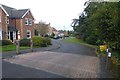
Queen Ethelburga's Park
Housing built on the site of a school which relocated to Thorpe Underwood.
Image: © DS Pugh
Taken: 7 Oct 2017
0.04 miles
2
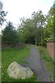
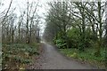
Cycle path to Jennyfield
Leading from Queen Ethelburga's Park skirting the edge of Oakdale golf course.
Image: © DS Pugh
Taken: 7 Oct 2017
0.05 miles
3
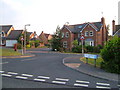
Queen Ethelburga's Park, Penny Pot Lane
This estate was built in the 1990s on the site of the former Queen Ethelburga's College after it moved to Thorpe Underwood. The postbox is number HG3 172.
Image: © Derek Harper
Taken: 29 Jun 2006
0.06 miles
4
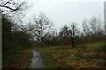
Path to Penny Pot Lane
Looking along a path connecting Queen Ethelburga's to Jennyfield.
Image: © DS Pugh
Taken: 29 Dec 2021
0.06 miles
5
Track off Penny Pot Lane
Looking along a track and across farmland from the road.
Image: © DS Pugh
Taken: 7 Oct 2017
0.07 miles
6
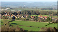
Queen Ethelburga's Park
Housing off Pennypot Lane seen from the same spot as Image] and Image This was built on the original site of Queen Ethelburga’s School, which moved to a new site in 1991. Away to the left are farm buildings and houses on Saltergate Hill.
Image: © Derek Harper
Taken: 1 Jan 2019
0.09 miles
7
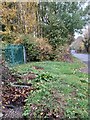
Harrogate, Penny Pot Lane
According to the OS benchmark database there was a culvert at this gated entrance, and a benchmark cut into the south side of the culvert. The culvert beyond the green gates, on the south side, has gone. The ditch has been updated with a new large bore concrete pipe and the ditch fully filled in. The alterations were made 10 - 15 years ago when new housing was built on the higher ground behind where I am stood taking the photo.
Image: © Mel Towler
Taken: 21 Oct 2022
0.11 miles
8
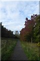
Path over Killinghall Moor
A cycle/foot path linking Queen Ethelburga's Park and Jennyfield.
Image: © DS Pugh
Taken: 7 Oct 2017
0.12 miles
9
Path in Queen Ethelburga's Estate
Looking along a path beside the playing fields.
Image: © DS Pugh
Taken: 29 Dec 2021
0.14 miles
10
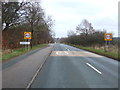
Entering Harrogate
Heading east on Penny Pot Lane.
Image: © JThomas
Taken: 10 Dec 2016
0.17 miles