IMAGES TAKEN NEAR TO
Grainbeck Lane, HARROGATE, HG3 2AA
Introduction
This page details the photographs taken nearby to Grainbeck Lane, HG3 2AA by members of the Geograph project.
The Geograph project started in 2005 with the aim of publishing, organising and preserving representative images for every square kilometre of Great Britain, Ireland and the Isle of Man.

There are currently over 7.5m images from over14,400 individuals and you can help contribute to the project by visiting https://www.geograph.org.uk
Image Map (Loading...)


Getting Data...Please wait
Leaflet Map data © OpenStreetMap
Images are licensed for reuse under creativecommons.org/licenses/by-sa/2.0
Notes
- Clicking on the map will re-center to the selected point.
- The higher the marker number, the further away the image location is from the centre of the postcode.
Image Listing (43 Images Found)
Images are licensed for reuse under creativecommons.org/licenses/by-sa/2.0
Image
Details
Distance

4
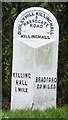
Old Milestone by the B6161, Otley Road, Killinghall
Metal plate attached to stone post by the B6161, in parish of KILLINGHALL (HARROGATE District), Otley Road, Killinghall, on the verge nearly opposite Moor Close, on West side of road. WR iron casting, erected by the County Council in the 19th century.
Inscription reads:-
: KILLING / HALL / ½ MILE : : DUDLEY HILL KILLINGHALL / & / HARROGATE / ROAD / KILLINGHALL : : BRADFORD / 20 MILES :
Grade II listed.
List Entry Number: 1173620 https://historicengland.org.uk/listing/the-list/list-entry/1173620
Milestone Society National ID: YN_BFKH20.
Image: © C Minto
Taken: 1 Sep 2001
0.10 miles
5
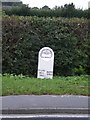
The Killinghall Milestone
Mid 19th century, erected possibly around 1838 when the turnpike road network locally was being enhanced, and Grade II listed https://britishlistedbuildings.co.uk/101173620-milepost-at-se-2833-5818-killinghall#.XHJ_tej7TIU in 1987.
Oh, and yes, it IS now slightly wonky - it's not the photographer's fault.
Image: © Richard Law
Taken: 12 Sep 2008
0.10 miles
7
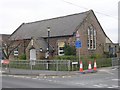
Killinghall Church of England Primary School - Otley Road
Image: © Betty Longbottom
Taken: 18 Apr 2009
0.12 miles
10
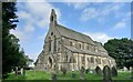
Killinghall, St Thomas's church
A wider angle showing the west facing front of the church. The benchmark is cut into the extreme right buttress of the front facia.
Image: © Mel Towler
Taken: 5 Sep 2021
0.14 miles