Old Milestone by the B6161, Otley Road, Killinghall
Introduction
The photograph on this page of Old Milestone by the B6161, Otley Road, Killinghall by C Minto as part of the Geograph project.
The Geograph project started in 2005 with the aim of publishing, organising and preserving representative images for every square kilometre of Great Britain, Ireland and the Isle of Man.

There are currently over 7.5m images from over 14,400 individuals and you can help contribute to the project by visiting https://www.geograph.org.uk
Old Milestone by the B6161, Otley Road, Killinghall
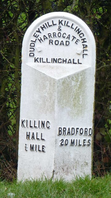
Image: © C Minto Taken: 1 Sep 2001
Metal plate attached to stone post by the B6161, in parish of KILLINGHALL (HARROGATE District), Otley Road, Killinghall, on the verge nearly opposite Moor Close, on West side of road. WR iron casting, erected by the County Council in the 19th century. Inscription reads:- : KILLING / HALL / ½ MILE : : DUDLEY HILL KILLINGHALL / & / HARROGATE / ROAD / KILLINGHALL : : BRADFORD / 20 MILES : Grade II listed. List Entry Number: 1173620 https://historicengland.org.uk/listing/the-list/list-entry/1173620 Milestone Society National ID: YN_BFKH20.
Images are licensed for reuse under creativecommons.org/licenses/by-sa/2.0
Image Location
Latitude
54.01905
Longitude
-1.568914