IMAGES TAKEN NEAR TO
Moor Park, HARROGATE, HG3 1RQ
Introduction
This page details the photographs taken nearby to Moor Park, HG3 1RQ by members of the Geograph project.
The Geograph project started in 2005 with the aim of publishing, organising and preserving representative images for every square kilometre of Great Britain, Ireland and the Isle of Man.

There are currently over 7.5m images from over14,400 individuals and you can help contribute to the project by visiting https://www.geograph.org.uk
Image Map (Loading...)


Getting Data...Please wait
Leaflet Map data © OpenStreetMap
Images are licensed for reuse under creativecommons.org/licenses/by-sa/2.0
Notes
- Clicking on the map will re-center to the selected point.
- The higher the marker number, the further away the image location is from the centre of the postcode.
Image Listing (3 Images Found)
Images are licensed for reuse under creativecommons.org/licenses/by-sa/2.0
Image
Details
Distance
1
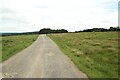
Track east of Springhill Farm
The track connecting Springhill Farm with the outside world. It is also a public footpath.
Image: © Graham Robson
Taken: 17 Jul 2020
0.20 miles
2
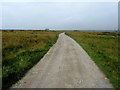
Track leading into Haverah Park
Substantial track leading from the B6161 at Beckwithshaw towards Springhill Farm and Haverah Park
Image: © Chris Heaton
Taken: 15 Aug 2012
0.22 miles
3
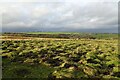
Digger working on moorland
Moorland north of a footpath running between Beckwithshaw and Scargill.
Image: © DS Pugh
Taken: 30 Dec 2024
0.24 miles