IMAGES TAKEN NEAR TO
Walton Park, HARROGATE, HG3 1RJ
Introduction
This page details the photographs taken nearby to Walton Park, HG3 1RJ by members of the Geograph project.
The Geograph project started in 2005 with the aim of publishing, organising and preserving representative images for every square kilometre of Great Britain, Ireland and the Isle of Man.

There are currently over 7.5m images from over14,400 individuals and you can help contribute to the project by visiting https://www.geograph.org.uk
Image Map
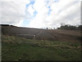
Images are licensed for reuse under creativecommons.org/licenses/by-sa/2.0
Notes
- Clicking on the map will re-center to the selected point.
- The higher the marker number, the further away the image location is from the centre of the postcode.
Image Listing (14 Images Found)
Images are licensed for reuse under creativecommons.org/licenses/by-sa/2.0
Image
Details
Distance
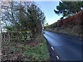
1
Pannal, Drury Lane
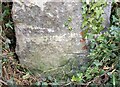
The benchmark is cut into the right hand gatepost at the entrance to Drury Lane End Farm on the south side of the lane.
Image: © Mel Towler
Taken: 14 Sep 2022
0.10 miles
2
Pannal, Drury Lane
There is a benchmark cut into the right hand gatepost at the entrance to Drury Lane End Farm on the south side of the lane.
Image: © Mel Towler
Taken: 14 Sep 2022
0.10 miles
3
Pannal, Rosemere
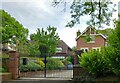
According to the OS benchmark database there is a benchmark cut on the west face of the property close to the north-west angle. The property is gated and no search was made.
Image: © Mel Towler
Taken: 2 Jun 2022
0.11 miles
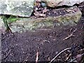
4
Pannal, Drury Lane
There is a benchmark cut into the roadside wall on the north side of the lane. It is the lowest stone at this wall corner.
Image: © Mel Towler
Taken: 15 Jan 2023
0.15 miles
5
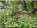
Pannal, Drury Lane road wall
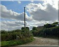
According to the OS benchmark database there is a cutmark on this stretch of dry stone wall on Drury Lane. Nothing was found but an easier search will be made in the winter.
Image: © Mel Towler
Taken: 2 Jun 2022
0.15 miles
6
Pannal, Drury Lane
The benchmark is cut into the roadside wall on the north side of the lane.
Image: © Mel Towler
Taken: 15 Jan 2023
0.16 miles
7
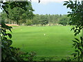
Pannal Golf Course
Seen through a gap in the trees from Drury Lane.
Image: © Gordon Hatton
Taken: 19 Jul 2023
0.20 miles
8
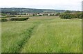
Path to Spacey Houses
Footpath 15 71/2/1 is about to become 15 54/86/1, as the hedge follows the parish boundary between Kirkby Overblow and Pannal. Spacey Houses, in the background, is in Image and Image
Image: © Derek Harper
Taken: 15 Jun 2011
0.23 miles
9
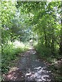
A section of old road
A section of the former Follifoot Lane on the south side of Drury Lane. On the other side of Drury Lane, the same route is now shown as a bridleway, but nothing is shown here. I'm not sure how far this old tarmacked surface runs.
Image: © Gordon Hatton
Taken: 19 Jul 2023
0.23 miles