IMAGES TAKEN NEAR TO
Jasper Lane, HARROGATE, HG3 1RD
Introduction
This page details the photographs taken nearby to Jasper Lane, HG3 1RD by members of the Geograph project.
The Geograph project started in 2005 with the aim of publishing, organising and preserving representative images for every square kilometre of Great Britain, Ireland and the Isle of Man.

There are currently over 7.5m images from over14,400 individuals and you can help contribute to the project by visiting https://www.geograph.org.uk
Image Map (Loading...)


Getting Data...Please wait
Leaflet Map data © OpenStreetMap
Images are licensed for reuse under creativecommons.org/licenses/by-sa/2.0
Notes
- Clicking on the map will re-center to the selected point.
- The higher the marker number, the further away the image location is from the centre of the postcode.
Image Listing (110 Images Found)
Images are licensed for reuse under creativecommons.org/licenses/by-sa/2.0
Image
Details
Distance
1
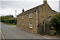
Compton Cottage on Barrowby Lane, Kirkby Overblow
Image: © Ian S
Taken: 16 Aug 2014
0.04 miles
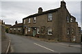
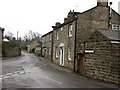
3

Older houses on Barrowby Lane, Kirkby Overblow
Rose Cottage and Lilac Cottage.
Image: © Stephen Craven
Taken: 3 Apr 2021
0.05 miles
4

Orchard Lane, Kirkby Overblow
The view across Wharfedale gives a good impression of the village's situation on the ridge. I guess it lives up to its name on a windy day.
Image: © Stephen Craven
Taken: 3 Apr 2021
0.06 miles
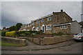
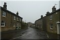
6

Newer houses on Barrowby Lane, Kirkby Overblow
Newer than most of the properties in the village.
Image: © Stephen Craven
Taken: 3 Apr 2021
0.06 miles
7
Lavender Cottage, Kirkby Overblow
With Rosemary Cottage to the left.
Image: © Ian S
Taken: 16 Aug 2014
0.06 miles
8
Swindon Lane, Kirkby Overblow
Houses on Swindon Lane in the village centre. In medieval times Kirkby Overblow was a centre for iron ore smelting [the 'Overblow' may have connections with smelting], with local low grade ores being brought here from locations mainly west and north of the village. This industry appears to have ended by the beginning of the 15th century, and Kirkby became just another agricultural settlement - until the age of the commuter.
Image: © Gordon Hatton
Taken: 30 Jan 2009
0.06 miles
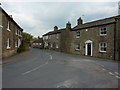
9
Barrowby Lane
Looking along Barrowby Lane from Swindon Lane in Kirkby Overblow.
Image: © DS Pugh
Taken: 23 Dec 2021
0.06 miles
10
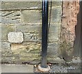
Kirkby Overblow, Lawrence House
The benchmark is cut into the road facing wall of the house, and to the left of the drainpipe.
Image: © Mel Towler
Taken: 18 Apr 2022
0.07 miles