IMAGES TAKEN NEAR TO
Rudding Lane, HARROGATE, HG3 1DQ
Introduction
This page details the photographs taken nearby to Rudding Lane, HG3 1DQ by members of the Geograph project.
The Geograph project started in 2005 with the aim of publishing, organising and preserving representative images for every square kilometre of Great Britain, Ireland and the Isle of Man.

There are currently over 7.5m images from over14,400 individuals and you can help contribute to the project by visiting https://www.geograph.org.uk
Image Map
Images are licensed for reuse under creativecommons.org/licenses/by-sa/2.0
Notes
- Clicking on the map will re-center to the selected point.
- The higher the marker number, the further away the image location is from the centre of the postcode.
Image Listing (19 Images Found)
Images are licensed for reuse under creativecommons.org/licenses/by-sa/2.0
Image
Details
Distance

4
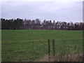
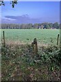
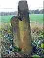
Milestone - Rudding Lane - Harrogate (5)
Old Milestone on Rudding Lane near Harrogate, this is a Milestone which has been used as the right hand gatepost at some point to what was probably a track across the field.
Milestone has inscriptions on all four sides for directions and distances to Spofforth (South East face), Leeds (South West face), Harrogate (North West Face) and Knaresborough (North East face).
Links to photos of all other faces can be seen below.
Image]
Image]
Image]
Image]
Image: © Tez Exley
Taken: 26 Sep 2023
0.12 miles
5
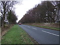
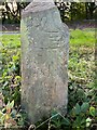
Milestone - Rudding Lane - Harrogate (1)
Old Milestone on Rudding Lane near Harrogate, this is a milestone which has been used as the right hand gatepost at some point to what was probably a track across the field . The building across the field to the North West is called Keepers Cottage.
Milestone has inscriptions on all four sides for directions and distances to Spofforth (South East face), Leeds (South West face), Harrogate (North West Face) and Knaresborough (North East face).
Links to photos of all four sides can be seen below.
Image]
Image]
Image]
Image]
Image: © Tez Exley
Taken: 26 Sep 2023
0.12 miles
6
Milestone - Rudding Lane - Harrogate (2)
Old Milestone on Rudding Lane near Harrogate, this is a Milestone which has been used as the right hand gatepost at some point to what was probably a track across the field . The building across the field to the North West is called Keepers Cottage.
Milestone has inscriptions on all four sides for directions and distances to Spofforth (South East face), Leeds (South West face), Harrogate (North West Face) and Knaresborough (North East face).
Links to photos of all other faces can be seen below.
Image]
Image]
Image]
Image]
Image: © Tez Exley
Taken: 26 Sep 2023
0.12 miles
7
Milestone - Rudding Lane - Harrogate (3)
Old Milestone on Rudding Lane near Harrogate, this is a Milestone which has been used as the right hand gatepost at some point to what was probably a track across the field.
Milestone has inscriptions on all four sides for directions and distances to Spofforth (South East face), Leeds (South West face), Harrogate (North West Face) and Knaresborough (North East face).
Links to photos of all other faces can be seen below.
Image]
Image]
Image]
Image]
Image: © Tez Exley
Taken: 26 Sep 2023
0.12 miles
8
Milestone - Rudding Lane - Harrogate (4)
Old Milestone on Rudding Lane near Harrogate, this is a Milestone which has been used as the right hand gatepost at some point to what was probably a track across the field.
Milestone has inscriptions on all four sides for directions and distances to Spofforth (South East face), Leeds (South West face), Harrogate (North West Face) and Knaresborough (North East face).
Links to photos of all other faces can be seen below.
Image]
Image]
Image]
Image]
Image: © Tez Exley
Taken: 26 Sep 2023
0.12 miles
9
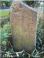
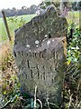
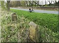
Old Guide stone, on Rudding Lane
Once located on the North side of Pannal Road; now on Rudding Lane, 10 metres beyond the Bends sign on the East side of road (obscured by bushes more recently). Carved stone post, erected originally by an unknown authority, 18th century.
Inscription reads: SW: ( hand ) / Roade to / Leed(s) / 9 Miles // SE: {Right pointing hand} / Roade to / Spofforth / 2 Miles // NE: {Right pointing hand} / Roade to / Knaresbr / ough {curved line} / 2 Miles // NW: {Right pointing hand} / Roade to / Harrogate / 1 Mile
Milestone Society National ID: YN_XFOL
Image: © Christine Minto
Taken: 17 Jan 2006
0.12 miles
10
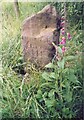
Old Guide stone, on Rudding Lane
Once located on the North side of Pannal Road; now on Rudding Lane, 10 metres beyond the Bends sign on the East side of road (obscured by bushes more recently). Carved stone post, erected originally by an unknown authority, 18th century. An earlier photograph can be found here https://www.geograph.org.uk/photo/6739333.
Inscription reads: SW: ( hand ) / Roade to / Leed(s) / 9 Miles // SE: {Right pointing hand} / Roade to / Spofforth / 2 Miles // NE: {Right pointing hand} / Roade to / Knaresbr / ough {curved line} / 2 Miles // NW: {Right pointing hand} / Roade to / Harrogate / 1 Mile
Milestone Society National ID: YN_XFOL
Image: © John Turner
Taken: 18 Apr 2020
0.12 miles