IMAGES TAKEN NEAR TO
Tewit Well Road, HARROGATE, HG2 8JJ
Introduction
This page details the photographs taken nearby to Tewit Well Road, HG2 8JJ by members of the Geograph project.
The Geograph project started in 2005 with the aim of publishing, organising and preserving representative images for every square kilometre of Great Britain, Ireland and the Isle of Man.

There are currently over 7.5m images from over14,400 individuals and you can help contribute to the project by visiting https://www.geograph.org.uk
Image Map
Images are licensed for reuse under creativecommons.org/licenses/by-sa/2.0
Notes
- Clicking on the map will re-center to the selected point.
- The higher the marker number, the further away the image location is from the centre of the postcode.
Image Listing (244 Images Found)
Images are licensed for reuse under creativecommons.org/licenses/by-sa/2.0
Image
Details
Distance
1
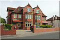
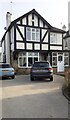
Semi-detached houses, Harrogate
A rather grand pair on Tewit Well Road.
Image: © Derek Harper
Taken: 23 Jun 2018
0.03 miles
2
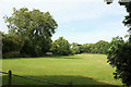
Oatlands Recreation Ground
From Cromwell Road showing the western corner.
Image: © Derek Harper
Taken: 23 Jun 2018
0.03 miles
3
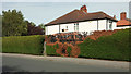
Burnt hedge, Tewit Well Road, Harrogate
I think someone must have had their barbecue too close to the other side of this hedge.
Image: © Derek Harper
Taken: 23 Jun 2018
0.04 miles
4
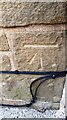
Benchmark on NE face, N angle of #55 Tewit Well Road
Ordnance Survey cut mark benchmark levelled at 131.927m above Newlyn Datum verified 1978
Image: © Roger Templeman
Taken: 14 Feb 2023
0.04 miles
5
#55 Tewit Well Road
There is an Ordnance Survey benchmark Image on the left hand side of the house near its front corner
Image: © Roger Templeman
Taken: 14 Feb 2023
0.05 miles
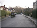
6
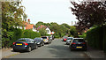
Wheatlands Grove, Harrogate
A short cul-de-sac leading away from Tewit Well Road.
Image: © Derek Harper
Taken: 23 Jun 2018
0.06 miles
7
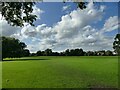
Oatlands recreation ground
A public open space occupying the site of a former brick works including an infilled clay pit.
Image: © Stephen Craven
Taken: 21 Sep 2023
0.06 miles
8
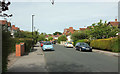
Tewit Well Road, Harrogate
Taken about 50 metres from its junction with Leeds Road behind the camera.
Image: © Derek Harper
Taken: 23 Jun 2018
0.07 miles
9
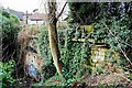
Brunswick tunnel south portal
Brunswick tunnel has been abandoned since 1862. It served the original Harrogate Brunswick station near the Stray for only 14 years before it closed. Built by the York and North Midland railway, the tunnel is now a forgotten relic of an enterprising age. There are more pictures and history of the Brunswick station and tunnel here http://blog.myspace.com/index.cfm?fuseaction=blog.view&friendID=265602590&blogID=351327703
Image: © philld
Taken: 26 Jan 2008
0.07 miles
10
Wheatlands Grove - Tewit Well Road
Image: © Betty Longbottom
Taken: 5 Dec 2009
0.07 miles