IMAGES TAKEN NEAR TO
Fountains Avenue, HARROGATE, HG1 4ER
Introduction
This page details the photographs taken nearby to Fountains Avenue, HG1 4ER by members of the Geograph project.
The Geograph project started in 2005 with the aim of publishing, organising and preserving representative images for every square kilometre of Great Britain, Ireland and the Isle of Man.

There are currently over 7.5m images from over14,400 individuals and you can help contribute to the project by visiting https://www.geograph.org.uk
Image Map (Loading...)


Getting Data...Please wait
Leaflet Map data © OpenStreetMap
Images are licensed for reuse under creativecommons.org/licenses/by-sa/2.0
Notes
- Clicking on the map will re-center to the selected point.
- The higher the marker number, the further away the image location is from the centre of the postcode.
Image Listing (49 Images Found)
Images are licensed for reuse under creativecommons.org/licenses/by-sa/2.0
Image
Details
Distance
5
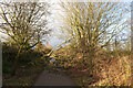
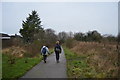
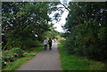
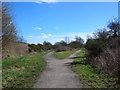
A fallen tree blocking the Nidderdale Greenway near Bilton, Harrogate
Image: © habiloid
Taken: 14 Jan 2023
0.13 miles
6
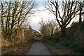
A fallen tree blocking the Nidderdale Greenway near Bilton, Harrogate
Image: © habiloid
Taken: 14 Jan 2023
0.13 miles
9
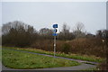
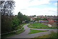
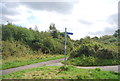
Cycle Routes
The fork in the former railway lines now provides cycle routes between Harrogate, Starbeck and Knaresborough. Take the left track for Starbeck, the right for Harrogate, or behind the camera to follow the quiet roads to Knaresborough.
Image: © DS Pugh
Taken: 31 Mar 2006
0.14 miles