IMAGES TAKEN NEAR TO
Knox Lane, HARROGATE, HG1 3AS
Introduction
This page details the photographs taken nearby to Knox Lane, HG1 3AS by members of the Geograph project.
The Geograph project started in 2005 with the aim of publishing, organising and preserving representative images for every square kilometre of Great Britain, Ireland and the Isle of Man.

There are currently over 7.5m images from over14,400 individuals and you can help contribute to the project by visiting https://www.geograph.org.uk
Image Map
Images are licensed for reuse under creativecommons.org/licenses/by-sa/2.0
Notes
- Clicking on the map will re-center to the selected point.
- The higher the marker number, the further away the image location is from the centre of the postcode.
Image Listing (24 Images Found)
Images are licensed for reuse under creativecommons.org/licenses/by-sa/2.0
Image
Details
Distance
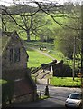
1
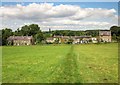
Houses on Knox Lane
Seen looking along footpath 15 54/1/1. Since Spruisty Bridge over the Oak Beck cannot be used by traffic, Knox Lane is a no through road for vehicles. The footpath is lined with electric fencing.
Image: © Derek Harper
Taken: 5 Jul 2014
0.05 miles
2
Harrogate, Knox Lane
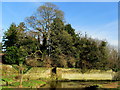
This is looking north towards Spruisty Bridge and Knox hamlet. This crossing point of Knox Lane is where the Old Barber rail line crossed Knox Lane and ran on to New Park, carrying coal for the gas works. According to the OS database on the bridge abutment to the right there was a benchmark. Today the foliage is so thick it is impossible to see if any of the bridge stonework remains, and if the cut mark is still present.
Image: © Mel Towler
Taken: 5 Sep 2021
0.11 miles
3
Bilton, Knox Lane, Barber Line abutment
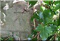
The benchmark is cut into the old railway bridge abutment for the Barber Line. It is on the east side of Knox Lane.
Image: © Mel Towler
Taken: 3 Apr 2022
0.12 miles
4
Bilton, Knox Lane, railway abutment
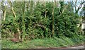
Behind this wall of thick foliage is the old railway bridge abutment for the Barber Line. It is on the east side of Knox Lane. There is a benchmark is cut into the stone work.
Image: © Mel Towler
Taken: 3 Apr 2022
0.12 miles
5
Oak Beck below Spruisty Bridge
The watercourse in Knox, north of Harrogate on its journey to join the River Nidd.
Image: © Chris Heaton
Taken: 16 Feb 2013
0.12 miles
6
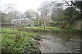
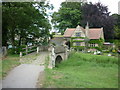
Ford at Knox
This ford on the Oak Beck is found at the end of Knox Mill Lane. The Six Dales Trail passes over the Spruisty packhorse bridge at this point.
Image: © John Walton
Taken: 15 Nov 2014
0.13 miles
7
Spruisty Bridge, Knox
A view of Image from footpath number 15 65/5/2. Knox Lane continues beyond the bridge towards Bilton.
Image: © Derek Harper
Taken: 1 Apr 2012
0.13 miles
8
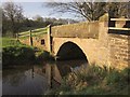
Spruisty Bridge, Knox
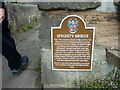
Another view of the listed bridge (downstream side) shown in http://www.geograph.org.uk/search.php?i=30145184 . As the Oak Beck is a parish boundary, the bridge is described twice, at http://www.britishlistedbuildings.co.uk/en-329888-spruisty-bridge-harrogate and http://www.britishlistedbuildings.co.uk/en-331539-spruisty-packhorse-bridge-over-oak-beck- ; the former doesn't seem to consider it C17.
Image: © Derek Harper
Taken: 1 Apr 2012
0.13 miles