IMAGES TAKEN NEAR TO
Penistone Road, HOLMFIRTH, HD9 7JL
Introduction
This page details the photographs taken nearby to Penistone Road, HD9 7JL by members of the Geograph project.
The Geograph project started in 2005 with the aim of publishing, organising and preserving representative images for every square kilometre of Great Britain, Ireland and the Isle of Man.

There are currently over 7.5m images from over14,400 individuals and you can help contribute to the project by visiting https://www.geograph.org.uk
Image Map
Images are licensed for reuse under creativecommons.org/licenses/by-sa/2.0
Notes
- Clicking on the map will re-center to the selected point.
- The higher the marker number, the further away the image location is from the centre of the postcode.
Image Listing (46 Images Found)
Images are licensed for reuse under creativecommons.org/licenses/by-sa/2.0
Image
Details
Distance
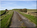
1
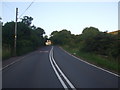
Penistone Road towards the Crossroads Inn
Image: © Glyn Drury
Taken: 7 Aug 2009
0.01 miles
2
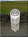
Old milestone
On the A635 from Shepley Lane Head down into New Mills and Holmfirth is a West Riding CC 19C milestone which is the last in the series east from Greenfield which used to be in Yorkshire. The tollroad from Greenfield to Shepley Lane Head was first enacted in 1823. The milestone is opposite Gate Foot Lane and a pub. This used to be the Crossroads PH then renamed Toss 'o Coin now derelict. This metal attachment has the name of the foundry on the bevel, Brayshaw & Booth/Makers/Liversedge. The stone is painted black. Grade II listed 1313617.
Image: © Chris Minto
Taken: 12 Jun 2022
0.02 miles
3
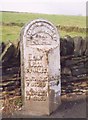
Old Milestone by the A635, Penistone Road, Fulstone
Metal plate attached to stone post by the A635, in parish of HOLME VALLEY (KIRKLEES District), Penistone Road, Fulstone, at junction with Gate Foot Lane, opposite Crossroads PH, in pavement, back to stone wall, on North side of road. Brayshaw & Booth iron casting, erected by the County Council in the 19th century.
Inscription reads:-
: DENBY / DALE / 3¾ MILES / CAWTHORNE / 7 MILES / BARNSLEY / 11 MILES : : GREENFIELD & SHEPLEY / LANE HEAD / ROAD / FULSTONE : : HOLMFIRTH / 3 MILES : Maker:-
: BRAYSHAW & BOOTH / MAKERS / LIVERSEDGE :
Grade II listed.
List Entry Number: 1313617 https://historicengland.org.uk/listing/the-list/list-entry/1313617
Milestone Society National ID: YW_GFSLH13.
Image: © C Minto
Taken: 1 Aug 2001
0.03 miles
5
Shepley Service Reservoir, Penistone Road
Service reservoirs are awkward to photograph, being on the top of hills! The water is pumped up to here, and then flows to Shepley by gravity. As it is treated water the reservoir has to be covered. This view is looking up the access drive from Penistone Road.
Image: © Humphrey Bolton
Taken: 5 Apr 2007
0.04 miles
6
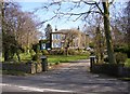
Grey Fell Academy, Penistone Road, Fulstone
A very pleasant place to be at school, although at 275m AOD and north-facing it is perhaps cold in the depths of Winter!
Image: © Humphrey Bolton
Taken: 5 Apr 2007
0.04 miles
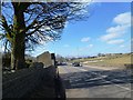
7
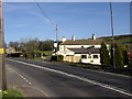
The Crossroads Inn, Penistone Road, Fulstone
This is where the old road to Penistone crosses the 'new' (1824 turnpike) road.
Image: © Humphrey Bolton
Taken: 5 Apr 2007
0.06 miles
8
The Crossroads Inn
View from Horn Lane looking across the main A635 and up Gate Foot Lane to the tiny and attractive hamlet of Gate Foot Image, nestling just about 1,000 feet up in the Pennines. The Crossroads Inn was once known as The Toss o'Coin because its ownership was decided by flipping a coin!
Image: © Barry Hurst
Taken: 4 May 2006
0.06 miles
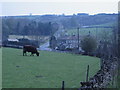
9
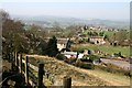
The view from Gate Foot
The urban area in the distance is Holmfirth, beyond which are the Pennines.
Image: © Graham Hogg
Taken: 28 Mar 2012
0.08 miles
10
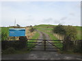
Entrance to the Shepley Service Reservoir
Image: © John Slater
Taken: 5 Oct 2014
0.08 miles