IMAGES TAKEN NEAR TO
The Bridges, HOLMFIRTH, HD9 7FE
Introduction
This page details the photographs taken nearby to The Bridges, HD9 7FE by members of the Geograph project.
The Geograph project started in 2005 with the aim of publishing, organising and preserving representative images for every square kilometre of Great Britain, Ireland and the Isle of Man.

There are currently over 7.5m images from over14,400 individuals and you can help contribute to the project by visiting https://www.geograph.org.uk
Image Map
Images are licensed for reuse under creativecommons.org/licenses/by-sa/2.0
Notes
- Clicking on the map will re-center to the selected point.
- The higher the marker number, the further away the image location is from the centre of the postcode.
Image Listing (34 Images Found)
Images are licensed for reuse under creativecommons.org/licenses/by-sa/2.0
Image
Details
Distance
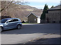
1
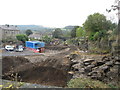
Work in progress east of Heys Road, Thongsbridge
This is part of the old Holmfirth railway line. The photo is taken from the Heys Road bridge. The Springwood Road bridge is visible above the digger in the centre of the photo. No indication of what is being built.
Image: © John Slater
Taken: 8 Oct 2014
0.02 miles
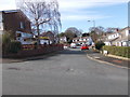
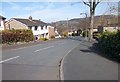
2
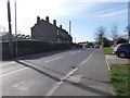
Miry Lane - viewed from Woodlands Avenue
Image: © Betty Longbottom
Taken: 15 Mar 2017
0.03 miles
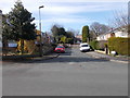
3
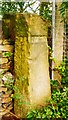
Old Guide Stone by Heys Road, Holmfirth
Was on UC road, in parish of Holme Valley (Kirklees District), Heys Road, Holmfirth, left side of entrance to Holme Valley Sports Centre (SE15120970).
Out of place - in public view
Milestone Society National ID: YW_XHOLM.
Image: © Milestone Society
Taken: Unknown
0.04 miles
4
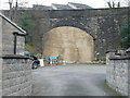
Walled-up railway bridge, Thongsbridge
This came as a surprise, as I had forgotten that Holmfirth had a railway, a branch of the Lancashire and Yorkshire Railway in 1893, but of the Huddersfield and Sheffield Junction Railway in 1850. Presumably the route along the valley was too difficult because of mills, so that the line had to climb steeply out of Holmfirth up to this bridge under Heys Road. Thongsbridge station was on the other side, and the OS map still shows a wooded area with two lines that might be the edges of the platforms. However, there is a building site there now - you can see the roofs of the new houses. The line continued over a high viaduct and along the eastern hillside on the Holme valley.
Image: © Humphrey Bolton
Taken: 11 Nov 2015
0.04 miles
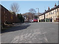
6
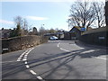
Springwood Road - viewed from near Woodlands Avenue
Image: © Betty Longbottom
Taken: 15 Mar 2017
0.05 miles