IMAGES TAKEN NEAR TO
Tor View, HOLMFIRTH, HD9 7BQ
Introduction
This page details the photographs taken nearby to Tor View, HD9 7BQ by members of the Geograph project.
The Geograph project started in 2005 with the aim of publishing, organising and preserving representative images for every square kilometre of Great Britain, Ireland and the Isle of Man.

There are currently over 7.5m images from over14,400 individuals and you can help contribute to the project by visiting https://www.geograph.org.uk
Image Map
Images are licensed for reuse under creativecommons.org/licenses/by-sa/2.0
Notes
- Clicking on the map will re-center to the selected point.
- The higher the marker number, the further away the image location is from the centre of the postcode.
Image Listing (62 Images Found)
Images are licensed for reuse under creativecommons.org/licenses/by-sa/2.0
Image
Details
Distance
7
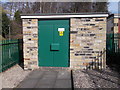
Electricity Substation No 2202 - Oakes Lane
Image: © Betty Longbottom
Taken: 15 Mar 2017
0.07 miles
8
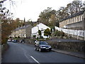
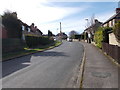
Brockholes Lane, Brockholes
The building on the right is the former primary school, now a village hall; there was a National (church) School there in 1850. The present school is behind. St George's Church, built in 1863, is in the distance.
Image: © Humphrey Bolton
Taken: 29 Nov 2005
0.08 miles