IMAGES TAKEN NEAR TO
New Mill Road, HOLMFIRTH, HD9 7AA
Introduction
This page details the photographs taken nearby to New Mill Road, HD9 7AA by members of the Geograph project.
The Geograph project started in 2005 with the aim of publishing, organising and preserving representative images for every square kilometre of Great Britain, Ireland and the Isle of Man.

There are currently over 7.5m images from over14,400 individuals and you can help contribute to the project by visiting https://www.geograph.org.uk
Image Map
Images are licensed for reuse under creativecommons.org/licenses/by-sa/2.0
Notes
- Clicking on the map will re-center to the selected point.
- The higher the marker number, the further away the image location is from the centre of the postcode.
Image Listing (64 Images Found)
Images are licensed for reuse under creativecommons.org/licenses/by-sa/2.0
Image
Details
Distance
1
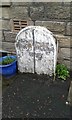
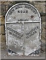
Old Boundary Marker
Parish Boundary Marker against the front wall of 347 Rock Terrace on the east side of the A616 New Mill Road, Brockholes. On the former boundary of Honley and Thurstonland townships, now in Holme Valley parish. Inscribed Boundary of Honley │ Boundary of Thurstonland / 1829 (below both and across the vertical line). Grade II Listed https://historicengland.org.uk/listing/the-list/list-entry/1134808.
Milestone Society National ID: YW_KIR03pb
Image: © D Garside
Taken: 7 Jan 2016
0.01 miles

5
Bus stop by Rock Cottages, New Mill Road, Brockholes
Image: © Chris
Taken: 11 Sep 2014
0.03 miles
6
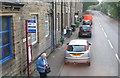
Old Milestone by the A616, New Mill Road, Brockholes
Metal plate attached to stone post by the A616, in parish of HOLME VALLEY (KIRKLEES District), New Mill Road, Brockholes, opposite junction with Brockholes Lane and Post Office, in narrow pavement, back to building, on West side of road. Brayshaw & Booth iron casting, erected by the County Council in the 19th century.
Inscription reads:-
: HUDDERSFIELD / 4½ MILES : : NEW MILL DISTRICT / ROAD / HONLEY : : SHEFFIELD / 22 MILES :
Maker:-
: BRAYSHAW & BOOTH / MAKERS / LIVERSEDGE :
Grade II listed.
List Entry Number: 1134831 https://historicengland.org.uk/listing/the-list/list-entry/1134831
Milestone Society National ID: YW_SFHU22
Image: © C Minto
Taken: 1 Sep 2001
0.04 miles
7
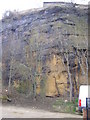
Cliff-face, close to New Mill Road, Brockholes
This quarried cliff-face was spotted down an entry road at the back of Bridge Works on New mill Road.
Image: © Brian Green
Taken: 15 Mar 2008
0.04 miles
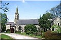
8
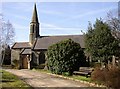
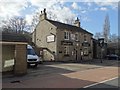
St George's Church, Brockholes, Honley
Another photograph of this church, which belongs to the parish of Honley.
Image: © Humphrey Bolton
Taken: 5 Apr 2007
0.04 miles
10
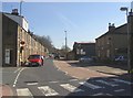
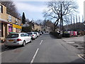
New Mill Road, Brockholes
The post office is on the left, at the junction with Brockholes Lane, and the Rock Inn on the right.
Image: © Humphrey Bolton
Taken: 5 Apr 2007
0.04 miles