IMAGES TAKEN NEAR TO
Oldfield, HOLMFIRTH, HD9 6RL
Introduction
This page details the photographs taken nearby to Oldfield, HD9 6RL by members of the Geograph project.
The Geograph project started in 2005 with the aim of publishing, organising and preserving representative images for every square kilometre of Great Britain, Ireland and the Isle of Man.

There are currently over 7.5m images from over14,400 individuals and you can help contribute to the project by visiting https://www.geograph.org.uk
Image Map
Images are licensed for reuse under creativecommons.org/licenses/by-sa/2.0
Notes
- Clicking on the map will re-center to the selected point.
- The higher the marker number, the further away the image location is from the centre of the postcode.
Image Listing (8 Images Found)
Images are licensed for reuse under creativecommons.org/licenses/by-sa/2.0
Image
Details
Distance
1

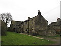
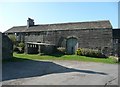
Part of Oldfield, Honley
This is a hamlet that existed in 1788 (although some of the houses have been rebuilt or new ones added since then), and the inhabitants then were probably mainly handloom weavers.
Image: © Humphrey Bolton
Taken: 28 Feb 2008
0.03 miles
2
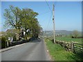
Oldfield Road, Honley
This was set out 30 feet wide in the enclosure award of 1788, when the common land to the north (Honley Moor) was enclosed. The land to the south (to the right in this view) had already been enclosed.
Image: © Humphrey Bolton
Taken: 19 Apr 2009
0.03 miles
3

Lane at Oldfield, Honley
The house on the left is the back of the former National School, with modern extensions. In the distance is a pair of early 19C houses with weaver's windows on first and second floors.
Image: © Humphrey Bolton
Taken: 28 Feb 2008
0.06 miles
4

The former National School, Oldfield, Honley
There are two inscriptions over the door: “Oldfield Church of England National School” and the date 1843 in Latin numerals, and “Restored 1874”. The land was purchased by Rev. Lewis Jones, Vicar of Almondbury "and other" from the Earl of Dartmouth on 1st June 1839.
Image: © Humphrey Bolton
Taken: 28 Feb 2008
0.06 miles
5
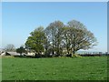
Ruin at Oldfield
Judging by the size of the trees, the building has been ruined for a long time. It is shown on the 1850 map, but only as a few walls on the 1960s map.
Image: © Humphrey Bolton
Taken: 19 Apr 2009
0.06 miles
8
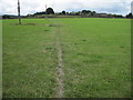
Upper Oldfield
The grassy lane to the left is still shown as a surfaced road on the OS map, but there is a gate at the other end.
Image: © Humphrey Bolton
Taken: 19 Apr 2009
0.23 miles