1
From Harden Hill Road towards Thick Hollins
Image: © Chris Wimbush
Taken: 11 Feb 2010
0.07 miles
2
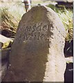
Milestone, Thick Hollins Road, Meltham
This is on the ancient route from Marsden to Penistone, and the distance to Marsden is shown as 4 miles. The Penistone side is badly worn, but W B Crump gives the distance as 11 miles and adds Holmfirth 2 Miles as being on the opposite face (ie along Wilshaw Road).
Image: © Humphrey Bolton
Taken: 16 Aug 2007
0.19 miles
3
Netherthong Road, Meltham
This is the old road, dropping steeply to the bridge over Thick Hollins Dike on its way to Meltham town. The road to the right is not quite as steep, and the lower section is called Coach Road, indicating that it was constructed as a safer route for wheeled vehicles, perhaps in the early 19C.
Image: © Humphrey Bolton
Taken: 16 Aug 2007
0.19 miles
4
Thick Hollins Road, Meltham
Now the main road down to Meltham town, but originally a continuation of Acre Side Road from Meltham Mills.
Image: © Humphrey Bolton
Taken: 16 Aug 2007
0.19 miles
5
Thick Hollins Road - viewed from Netherthong Road
Image: © Betty Longbottom
Taken: 4 Apr 2017
0.20 miles
6
Harden Hill Road
Looking Back towards Meltham
Image: © Nigel Homer
Taken: 26 Feb 2006
0.21 miles
7
House 'Rigtersbleek' on Netherthong Road
Image: © John Slater
Taken: 24 Nov 2012
0.22 miles
8
Old milestone
This is one of three remaining roadside guidestones/milestones in the West Yorkshire area of the Dark Peak. A fourth is in the Tolson Museum, Huddersfield. It is at the SE corner of Wilshaw Road (B6107) with Thick Hollins Road. On the right-hand face Penist/11 Mile can just be made out. On the back a faint Holmfirth/2 Miles. In 'Huddersfield Highways Down the Ages' by WB Crump (1949) a sketch shows the date 1761 on the Holmfirth face. When first recorded for the Milestone Society in 2002 it was leaning considerably but by 2005 had been set upright.
Image: © Chris Minto
Taken: 14 Aug 2021
0.22 miles
9
Old Milestone by the B6107, Thick Hollins Road, Meltham parish
Stone post by the B6107, in parish of Meltham (Kirklees District), Thick Hollins, junction of Thick Hollins Road with Wilshaw Road, Southeast corner of junction.
Inscription reads:-
: Marsden / 4 Miles : : Penis(tone) / (1)1 Miles : : Holmfirth / (2) Miles :
: (1761) : : {hand} :
Grade II listed.
List Entry Number: 1184090 https://historicengland.org.uk/listing/the-list/list-entry/1184090
Surveyed
Milestone Society National ID: YW_XMELb
Image: © Milestone Society
Taken: Unknown
0.22 miles
10
Junction on Netherhong Road
Joining the B6107.
Image: © JThomas
Taken: 15 Nov 2018
0.22 miles


