IMAGES TAKEN NEAR TO
Newlands Lane, HOLMFIRTH, HD9 3RL
Introduction
This page details the photographs taken nearby to Newlands Lane, HD9 3RL by members of the Geograph project.
The Geograph project started in 2005 with the aim of publishing, organising and preserving representative images for every square kilometre of Great Britain, Ireland and the Isle of Man.

There are currently over 7.5m images from over14,400 individuals and you can help contribute to the project by visiting https://www.geograph.org.uk
Image Map
Images are licensed for reuse under creativecommons.org/licenses/by-sa/2.0
Notes
- Clicking on the map will re-center to the selected point.
- The higher the marker number, the further away the image location is from the centre of the postcode.
Image Listing (19 Images Found)
Images are licensed for reuse under creativecommons.org/licenses/by-sa/2.0
Image
Details
Distance
1
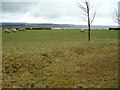
Newlands Lane, near Upperthong
Heading up path towards Newlands from Greenfield Road.
Image: © Samantha Waddington
Taken: 13 Apr 2013
0.03 miles
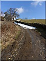
2
Pennine track below Upperthong
It will shortly meet the A635 which is down in the dip.
Image: © Bill Boaden
Taken: 12 Sep 2014
0.04 miles
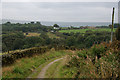
3
Flat Lane, Upperthong
Heading along track past Nether House farm, west of Upperthong. The 'tops' of Holme Moss can be seen in the distance.
Image: © Samantha Waddington
Taken: 13 Apr 2013
0.13 miles
4
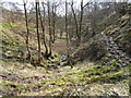
Hart Holes Clough, near Holmfirth
Looking east down the clough towards Holmfirth.
Image: © Samantha Waddington
Taken: 13 Apr 2013
0.15 miles


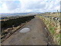
7

Black Sike Lane, near Hogley Green
Heading up lane from Harts Hole Clough towards the hamlet of Hogley Green.
Image: © Samantha Waddington
Taken: 13 Apr 2013
0.17 miles
8
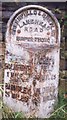
Old Milestone by the A635, Greenfield Road, west of Holmfirth
Metal plate attached to stone post by the A635, in parish of Holme Valley (Kirklees District), Greenfield Road, Upperthorpe, Holmfirth, by electricity pylon 196, just above bus turning circle on opposite side of road, on North side of road. Brayshaw & Booth iron casting, erected by the County Council in the 19th century.
Inscription reads:-
: HOLMFIRTH / 1 MILE / BARNSLEY / 15 MILES : : GREENFIELD & SHEPLEY / LANE HEAD / ROAD / UPPERTHONG : : GREEN / FIELD / 9½ MILES / OLDHAM / 13¾ MILES :
Maker:-
: BRAYSHAW & BOOTH / MAKERS / LIVERSEDGE :
Grade II Listed.
List Entry Number: 1134872 https://historicengland.org.uk/listing/the-list/list-entry/1134872
Milestone Society National ID: YW_GFSLH09
Image: © C Minto
Taken: 25 Sep 2002
0.17 miles
9
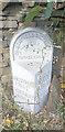
Old Milestone by the A635, Greenfield Road, west of Holmfirth
Metal plate attached to stone post by the A635, in parish of Holme Valley (Kirklees District), Greenfield Road, Upperthorpe, Holmfirth, by electricity pylon 196, just above bus turning circle on opposite side of road, on North side of road. Brayshaw & Booth iron casting, erected by the County Council in the 19th century. An earlier photograph can be seen here https://www.geograph.org.uk/photo/6102142.
Inscription reads:-
: HOLMFIRTH / 1 MILE / BARNSLEY / 15 MILES : : GREENFIELD & SHEPLEY / LANE HEAD / ROAD / UPPERTHONG : : GREEN / FIELD / 9½ MILES / OLDHAM / 13¾ MILES :
Maker:-
: BRAYSHAW & BOOTH / MAKERS / LIVERSEDGE :
Grade II Listed.
List Entry Number: 1134872 https://historicengland.org.uk/listing/the-list/list-entry/1134872
Milestone Society National ID: YW_GFSLH09
Image: © Nigel Upton
Taken: 24 Sep 2022
0.17 miles