IMAGES TAKEN NEAR TO
Wheat Close, HOLMFIRTH, HD9 2QL
Introduction
This page details the photographs taken nearby to Wheat Close, HD9 2QL by members of the Geograph project.
The Geograph project started in 2005 with the aim of publishing, organising and preserving representative images for every square kilometre of Great Britain, Ireland and the Isle of Man.

There are currently over 7.5m images from over14,400 individuals and you can help contribute to the project by visiting https://www.geograph.org.uk
Image Map
Images are licensed for reuse under creativecommons.org/licenses/by-sa/2.0
Notes
- Clicking on the map will re-center to the selected point.
- The higher the marker number, the further away the image location is from the centre of the postcode.
Image Listing (20 Images Found)
Images are licensed for reuse under creativecommons.org/licenses/by-sa/2.0
Image
Details
Distance
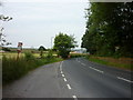
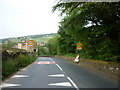
2
Woodhead Road between Holme and Holmbridge
Image: © Neil Theasby
Taken: 10 Sep 2020
0.04 miles
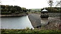
5
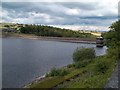
Brownhill Reservoir, Dam Wall and Valve Tower
Image: © Jonathan Clitheroe
Taken: 25 Jul 2015
0.10 miles
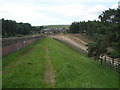
6
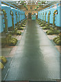
Inside the old filter house, Brownhill
These were the sand-filled pressure filters that treated the water from the adjacent Brownhill reservoir. They were removed in 1994 when the works was superseded by the new plant at Rusby Wood (in Image - no Geograph yet). I do not know whether the building itself still stands.
Image: © Stephen Craven
Taken: Unknown
0.12 miles
7
The dam, Brownhill reservoir
Batley Corporation Water Board opened this reservoir in 1932.
Image: © Christine Johnstone
Taken: 26 Jun 2020
0.13 miles
8
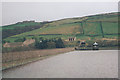
Brownhill Reservoir
Brownhill dam was built in the 1930s. When this reservoir is full, the long-term settlement of the earth dam can be clearly seen (follow the line of the bottom of the wave wall, compared with the water surface which must be horizontal). In the middle distance is the valve tower, and the buildings on the far side are the water treatment works.
Image: © Stephen Craven
Taken: 8 Apr 1998
0.13 miles
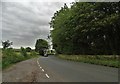
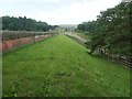
10
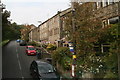
Woodhead Road out of Holmbridge
Not sure what the bunting is in aid of.
Image: © Chris
Taken: 11 Sep 2014
0.17 miles