IMAGES TAKEN NEAR TO
Laithe Avenue, HOLMFIRTH, HD9 2PJ
Introduction
This page details the photographs taken nearby to Laithe Avenue, HD9 2PJ by members of the Geograph project.
The Geograph project started in 2005 with the aim of publishing, organising and preserving representative images for every square kilometre of Great Britain, Ireland and the Isle of Man.

There are currently over 7.5m images from over14,400 individuals and you can help contribute to the project by visiting https://www.geograph.org.uk
Image Map
Images are licensed for reuse under creativecommons.org/licenses/by-sa/2.0
Notes
- Clicking on the map will re-center to the selected point.
- The higher the marker number, the further away the image location is from the centre of the postcode.
Image Listing (52 Images Found)
Images are licensed for reuse under creativecommons.org/licenses/by-sa/2.0
Image
Details
Distance
1
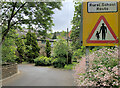
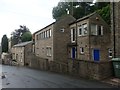
Dobb Top Road, Holmbridge
The sign on the right is one of a few in the area, presumably to warn of pedestrian children and parents trying to reach the nearby primary school along winding roads with narrow or non-existent footways.
Image: © Paul Harrop
Taken: 28 May 2023
0.10 miles
7
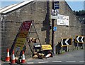
Clutter
Signs in abundance in Holmbridge.
Image: © Steve Fareham
Taken: 8 Jun 2008
0.17 miles
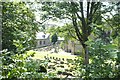
8
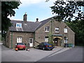
Housing on Bank Lane, Holmbridge
Newer housing above an older house.
Image: © Christine Johnstone
Taken: 26 Jun 2020
0.18 miles

10
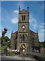
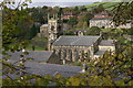
St David's Holmbridge
Complete with the local Silver Band.
Image: © Steve Fareham
Taken: 8 Jun 2008
0.18 miles