IMAGES TAKEN NEAR TO
Bankfield Drive, HOLMFIRTH, HD9 2PH
Introduction
This page details the photographs taken nearby to Bankfield Drive, HD9 2PH by members of the Geograph project.
The Geograph project started in 2005 with the aim of publishing, organising and preserving representative images for every square kilometre of Great Britain, Ireland and the Isle of Man.

There are currently over 7.5m images from over14,400 individuals and you can help contribute to the project by visiting https://www.geograph.org.uk
Image Map
Images are licensed for reuse under creativecommons.org/licenses/by-sa/2.0
Notes
- Clicking on the map will re-center to the selected point.
- The higher the marker number, the further away the image location is from the centre of the postcode.
Image Listing (48 Images Found)
Images are licensed for reuse under creativecommons.org/licenses/by-sa/2.0
Image
Details
Distance
2
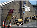
Clutter
Signs in abundance in Holmbridge.
Image: © Steve Fareham
Taken: 8 Jun 2008
0.11 miles
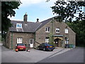
4
Housing on Bank Lane, Holmbridge
Newer housing above an older house.
Image: © Christine Johnstone
Taken: 26 Jun 2020
0.11 miles
8
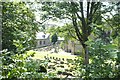
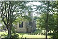
St.David's Parish Church, Holmbridge
Right in the heart of Summer Wine country
Image: © Roger May
Taken: 7 Aug 2005
0.13 miles
9
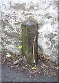
Old Boundary Marker
County Bridge Marker on A6024 Woodhead Road, Holmbridge. Holme Valley parish. Inscribed County vertically. The stone marks the extent of roadway adjoining the bridge that the County was obliged to maintain. See also https://www.geograph.org.uk/photo/1112612
Milestone Society National ID: YW_HOLM02br
Image: © R Heywood
Taken: 27 Aug 2019
0.13 miles
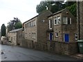
10
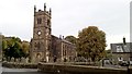
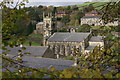
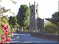
St. David's Church, Woodhead Road, Holmbridge
Church is Grade II listed and dates to about 1838-40, see; https://huddersfield.exposed/wiki/St._David%27s_Church,_Woodhead_Road,_Holmbridge
Image: © Chris Morgan
Taken: 16 Oct 2018
0.13 miles