IMAGES TAKEN NEAR TO
Royd Lane, HOLMFIRTH, HD9 2JA
Introduction
This page details the photographs taken nearby to Royd Lane, HD9 2JA by members of the Geograph project.
The Geograph project started in 2005 with the aim of publishing, organising and preserving representative images for every square kilometre of Great Britain, Ireland and the Isle of Man.

There are currently over 7.5m images from over14,400 individuals and you can help contribute to the project by visiting https://www.geograph.org.uk
Image Map
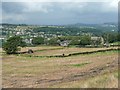
Images are licensed for reuse under creativecommons.org/licenses/by-sa/2.0
Notes
- Clicking on the map will re-center to the selected point.
- The higher the marker number, the further away the image location is from the centre of the postcode.
Image Listing (18 Images Found)
Images are licensed for reuse under creativecommons.org/licenses/by-sa/2.0
Image
Details
Distance
1
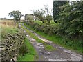
Old Yew Lane, off Royd Lane, Cartworth
This was a lane through to Hill House Road, but now looks to be just a driveway to Old Yew, the house in the photo. This was on the 1850 map, but might have been altered later in the 19C. There is also a modern house to the right.
Image: © Humphrey Bolton
Taken: 12 Oct 2006
0.01 miles
2
Old Yew, Cartworth
Often there is now a small group of houses where there was originally a farm.
Image: © Humphrey Bolton
Taken: 21 Aug 2008
0.01 miles
3
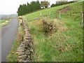
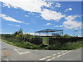
Disused well, Royd Lane, Cartworth
Now walled off from the road. The well seems to be under vegetation in the centre of the retaining wall on the right. Marked as a trough on the 1850 6" map.
Image: © Humphrey Bolton
Taken: 12 Oct 2006
0.06 miles
4
Hill House Road, Cartworth
A public footpath slopes up to the left, opposite Nether Hill House Farm.
Image: © Humphrey Bolton
Taken: 21 Aug 2008
0.12 miles
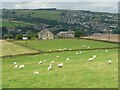
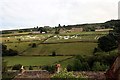
5
Fields at Nether Hill House, Cartworth
Taken from Hill House Road. Whatever was grown in the fields has been harvested.
Image: © Humphrey Bolton
Taken: 21 Aug 2008
0.13 miles
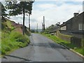
6
A wet road, Hill House Road, Cartworth
Water is running down the road from a recent shower, forming a pattern especially on the right. The footpath sign is for Dunsley Road, which goes to the left up the hillside.
Image: © Humphrey Bolton
Taken: 21 Aug 2008
0.13 miles
7
Upper Water Side, Royd Lane, Cartworth
This farm is on the 1850 6" map. The hamlet of Hinchliffe Mill is in the distance down in the Holme valley.
Image: © Humphrey Bolton
Taken: 12 Oct 2006
0.14 miles
8
Field painting for 'Le Grand D?part'
The 2014 Tour de France started in Yorkshire and on day 2 finished in Sheffield. This grass field in the Holme Valley celebrates the event with a cycle-themed artwork.
Image: © Graham Hogg
Taken: 3 Jul 2014
0.16 miles
9
Cartworth moor cricket ground.
An out of the way spot for a cricket ground.
Image: © steven ruffles
Taken: 30 Jun 2015
0.19 miles
10
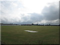
Cartworth Moor Cricket Club ground
Club established 1887
Image: © John Slater
Taken: 5 Aug 2014
0.19 miles