IMAGES TAKEN NEAR TO
Dunford Road, HOLMFIRTH, HD9 2DE
Introduction
This page details the photographs taken nearby to Dunford Road, HD9 2DE by members of the Geograph project.
The Geograph project started in 2005 with the aim of publishing, organising and preserving representative images for every square kilometre of Great Britain, Ireland and the Isle of Man.

There are currently over 7.5m images from over14,400 individuals and you can help contribute to the project by visiting https://www.geograph.org.uk
Image Map
Images are licensed for reuse under creativecommons.org/licenses/by-sa/2.0
Notes
- Clicking on the map will re-center to the selected point.
- The higher the marker number, the further away the image location is from the centre of the postcode.
Image Listing (29 Images Found)
Images are licensed for reuse under creativecommons.org/licenses/by-sa/2.0
Image
Details
Distance
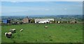
1
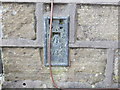
Ordnance Survey Flush Bracket 734
This can be found on the wall of the former Junction Inn (now Junction House).
For more detail see : http://www.bench-marks.org.uk/log?bm_key=719
Image: © Peter Wood
Taken: 3 Mar 2013
0.00 miles
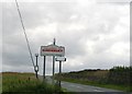
3
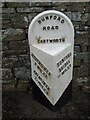
Old milestone
There are just two 19C West Riding CC milestones on Dunford Road from the B6106 at Hade Edge towards Dunford Bridge. This one is just south of the West Yorkshire/South Yorkshire boundary at the Bare Bones Road/Flight Hill cross-roads. Both have been painted expertly recently and the foundry name, Brayshaw & Booth, Liversedge is on the bevel.
Milestone Society National ID: YW_HUDB09
Image: © Chris Minto
Taken: 12 Jun 2022
0.01 miles
4
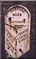
Old Milestone, on junction of Dunford Road with Bare Bones Road / Flight Hill
Located on the West side of road, just south of X roads. Metal plate attached to stone post, Brayshaw & Booth casting design, erected by Wadsley & Langsett - Holmfirth District turnpike trust, 19th century.
Inscription reads: HUDDERSFIELD / 9 MILES / HOLMFIRTH / 2 ½ MILES // DUNFORD / BRIDGE / 1¼ MILES // DUNFORD / ROAD / CARTWORTH // BRAYSHAW & BOOTH / MAKERS / LIVERSEDGE
Grade II listed by Historic England. see https://historicengland.org.uk/listing/the-list/list-entry/1151137
Milestone Society National ID: YW_HUDB09
Image: © Christine Minto
Taken: 4 Jan 2006
0.01 miles
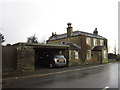
7
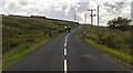
Flight Hill
View looking up Flight Hill.
Image: © Peter McDermott
Taken: 27 Jun 2015
0.11 miles
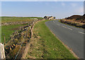
8
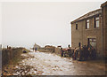
Snittlegate
A wet winter's day above Holmfirth and a muddy walk along this unsurfaced road.
Image: © Stephen Craven
Taken: 22 Nov 1992
0.13 miles
10
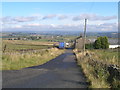
Dunford Road towards Dunford Bridge
The house is Lamb's Cote.
Image: © Andrew Tatlow
Taken: 23 Apr 2015
0.14 miles