IMAGES TAKEN NEAR TO
Hade Edge, HOLMFIRTH, HD9 1RW
Introduction
This page details the photographs taken nearby to HD9 1RW by members of the Geograph project.
The Geograph project started in 2005 with the aim of publishing, organising and preserving representative images for every square kilometre of Great Britain, Ireland and the Isle of Man.

There are currently over 7.5m images from over14,400 individuals and you can help contribute to the project by visiting https://www.geograph.org.uk
Image Map
Images are licensed for reuse under creativecommons.org/licenses/by-sa/2.0
Notes
- Clicking on the map will re-center to the selected point.
- The higher the marker number, the further away the image location is from the centre of the postcode.
Image Listing (27 Images Found)
Images are licensed for reuse under creativecommons.org/licenses/by-sa/2.0
Image
Details
Distance
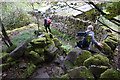
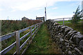
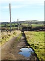
3
The Kirklees Way leaving Upper House towards Hepworth
This bridge is alongside rather than across the stream. The path follows the stream through woodland, crossing it several times by footbridges and once on stepping stones. It is very rough and not at all 'granny-friendly'.
Image: © Humphrey Bolton
Taken: 25 Jun 2021
0.04 miles
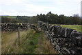
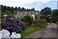
9
Track to New Upperhouse Farm near Abinger
Image: © Neil Theasby
Taken: 17 Dec 2013
0.10 miles
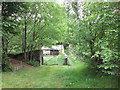
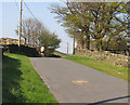
10
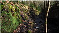
Path through Morton Wood, Dean Dike near Hepworth
Image: © Colin Park
Taken: 8 Mar 2022
0.12 miles