IMAGES TAKEN NEAR TO
Factory Lane, HUDDERSFIELD, HD8 9TE
Introduction
This page details the photographs taken nearby to Factory Lane, HD8 9TE by members of the Geograph project.
The Geograph project started in 2005 with the aim of publishing, organising and preserving representative images for every square kilometre of Great Britain, Ireland and the Isle of Man.

There are currently over 7.5m images from over14,400 individuals and you can help contribute to the project by visiting https://www.geograph.org.uk
Image Map
Images are licensed for reuse under creativecommons.org/licenses/by-sa/2.0
Notes
- Clicking on the map will re-center to the selected point.
- The higher the marker number, the further away the image location is from the centre of the postcode.
Image Listing (4 Images Found)
Images are licensed for reuse under creativecommons.org/licenses/by-sa/2.0
Image
Details
Distance
1
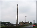
Farm buildings at SE 223 133 near Emley Moor Mast.
Looking S.
Image: © Steve Partridge
Taken: 31 Aug 2005
0.20 miles
2
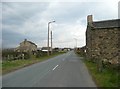
Common Lane, Emley
A dead straight road set out when Emley Moor was enclosed. On the right is what appears to be the lower part of an old street laight column.
Image: © Humphrey Bolton
Taken: 10 Apr 2008
0.20 miles
3
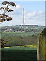
Emley Moor TV mast
The Emley Moor TV mast towering above the surrounding countryside.
Image: © Dave Pickersgill
Taken: 30 Apr 2012
0.22 miles
4
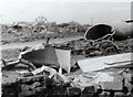
Mast Wreckage
Wreckage of the Emley Moor Mast, which crashed in March 1969, strewn across fields.
For more information see John Carter's photograph Image taken a few week's earlier.
Image: © Gerald England
Taken: 11 May 1969
0.24 miles