1
Shepley - view towards Emley Moor
Image: © Dave Bevis
Taken: 20 Aug 2005
0.01 miles
2
Firth Bros, Shepley New Mill
Colin Bowden the author of two books on stationary steam engines captured this image of the Wood Bros of Sowerby Bridge inverted vertical triple expansion steam engine at this Yorkshire woollen mill. It was built in 1906 and was installed here, third-hand, in 1939. It was standby from 1959 and is believed to have last run in 1980. It was pressed in to service following the fall of the Emley moor transmitter and in the miners' strikes of the 1970s. It was good for 600 horsepower at 80 rpm and drove the alternator in the right foreground by Vee-belts from the 15' diameter flywheel.
It was removed for preservation by the Yorkshire Branch of the Northern Mill Engine Society but a permanent home could not be found and it ended in open air store at a privately owned steam museum. It was scrapped in 2008. It was the very last engine of this type to have worked in a mill (although several water works examples survive).
Image: © Colin Bowden
Taken: 22 Mar 1977
0.06 miles
3
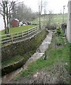
Shepley Dike looking downstream from Stretch Gate
There looks to be a pipe crossing the stream bed. The stream is the boundary between Shelley, on the left, and Shepley. The area to the right is the sitebof Shepley New Mills and is being developed for housing after being derelict for many years.
Image: © Humphrey Bolton
Taken: 4 Nov 2021
0.10 miles
4
Abbey Road, Shelley
Image: © Chris Morgan
Taken: 10 Jan 2022
0.10 miles
5
Beck upstream of Shelley Bank Bottom
The water was brown due to the recent rain.
Image: © Humphrey Bolton
Taken: 17 Apr 2008
0.11 miles
6
Boundary stone, Shelley Bank Bottom
Unfortunately the top layer of the sandstone has peeled off on the left side, which should read “Shepley”. Strange that two adjacent townships should have such similar names. The iron plates are for Huddersfield Corporation Water Works mains.
Image: © Humphrey Bolton
Taken: 17 Apr 2008
0.11 miles
7
A629 at Shelley village boundary
Image: © Colin Pyle
Taken: 11 Mar 2017
0.11 miles
8
Stretch Gate climbing up to Penistone Road, Shelley
This comes out opposite Far Bank. There is an easier route to the right.
Image: © Humphrey Bolton
Taken: 4 Nov 2021
0.12 miles
9
Entering Shelley
Heading north east on the A629.
Image: © JThomas
Taken: 3 Oct 2014
0.12 miles
10
Old Boundary Marker by the A629, Penistone Road/Abbey Road
Parish Boundary Marker by the A629, in parish of Kirkburton (Kirklees District), Shelley Bank Bridge, West side of A629 bridge over Shelley/Shepley Dike. Shelley is North of the dike, and Shepley is south of the dike.
Inscription reads:- : (SHEPLEY) | SHELLEY :
Surveyed
Milestone Society National ID: YW_SHESHP01pb.
Image: © Milestone Society
Taken: Unknown
0.13 miles


