IMAGES TAKEN NEAR TO
Station Road, HUDDERSFIELD, HD8 8AA
Introduction
This page details the photographs taken nearby to Station Road, HD8 8AA by members of the Geograph project.
The Geograph project started in 2005 with the aim of publishing, organising and preserving representative images for every square kilometre of Great Britain, Ireland and the Isle of Man.

There are currently over 7.5m images from over14,400 individuals and you can help contribute to the project by visiting https://www.geograph.org.uk
Image Map
Images are licensed for reuse under creativecommons.org/licenses/by-sa/2.0
Notes
- Clicking on the map will re-center to the selected point.
- The higher the marker number, the further away the image location is from the centre of the postcode.
Image Listing (54 Images Found)
Images are licensed for reuse under creativecommons.org/licenses/by-sa/2.0
Image
Details
Distance
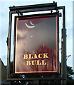
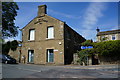
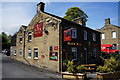
3
Station Road, Shepley
The Black Bull Pub can be seen at the junction
Image: © Nigel Homer
Taken: 5 Feb 2006
0.02 miles
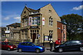
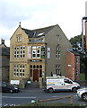
4
Former New Connexion Schools
Built in 1875 on Marsh Lane, Shepley.
Image: © Ian S
Taken: 8 May 2015
0.03 miles
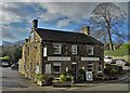
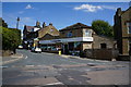
7
Black Bull, Shepley
http://www.geograph.org.uk/photo/4470621
Image: © Ian S
Taken: 8 May 2015
0.03 miles
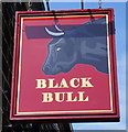
8
Black Bull, Shepley
http://www.geograph.org.uk/photo/4470626
Image: © Ian S
Taken: 8 May 2015
0.03 miles
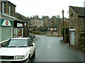
9
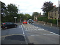
Abbey Road South (A629), Shepley
Heading north east towards Huddersfield.
Image: © JThomas
Taken: 3 Oct 2014
0.03 miles