IMAGES TAKEN NEAR TO
Queens Way, HUDDERSFIELD, HD8 0SP
Introduction
This page details the photographs taken nearby to Queens Way, HD8 0SP by members of the Geograph project.
The Geograph project started in 2005 with the aim of publishing, organising and preserving representative images for every square kilometre of Great Britain, Ireland and the Isle of Man.

There are currently over 7.5m images from over14,400 individuals and you can help contribute to the project by visiting https://www.geograph.org.uk
Image Map
Images are licensed for reuse under creativecommons.org/licenses/by-sa/2.0
Notes
- Clicking on the map will re-center to the selected point.
- The higher the marker number, the further away the image location is from the centre of the postcode.
Image Listing (57 Images Found)
Images are licensed for reuse under creativecommons.org/licenses/by-sa/2.0
Image
Details
Distance
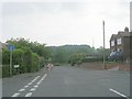
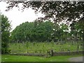
2
Graveyard - All Hallows - off Huddersfield Road
Image: © Betty Longbottom
Taken: 5 Jun 2010
0.11 miles
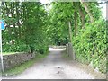
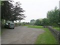
3
Box Ings Lane, Kirkburton
A dead end lane leading to a farm and a few private properties, but it also forms part of the Trans Pennine Trail and this has the status of a public bridleway.
Image: © Diocese of Leeds
Taken: 26 Feb 2020
0.12 miles
4
Bridleway - Box Ings Lane - Huddersfield Road
Image: © Betty Longbottom
Taken: 5 Jun 2010
0.12 miles
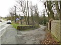
6
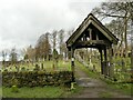
All Hallows, Kirkburton: bottom churchyard entrance
The gateway from Box Ings Lane. There is a plaque dedicating it to the memory of Harriet Shaw, died 1935.
Image: © Diocese of Leeds
Taken: 26 Feb 2020
0.13 miles
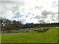
7
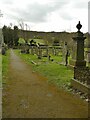
All Hallows, Kirkburton: upper churchyard (3)
Looking towards the bottom entrance from Box Ings Lane.
Image: © Diocese of Leeds
Taken: 26 Feb 2020
0.13 miles
8
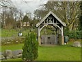
All Hallows, Kirkburton: entrance to lower churchyard
The lower churchyard is a later addition. This northern end of it occupies the site of the former Box Ings Colliery. The gateway takes the form of a lych gate though was probably not intended to be used as such as it has no benches.
Image: © Diocese of Leeds
Taken: 26 Feb 2020
0.13 miles
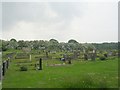
9
Graveyard - All Hallowes - Huddersfield Road
Image: © Betty Longbottom
Taken: 5 Jun 2010
0.13 miles
10
All Hallows, Kirkburton: lower churchyard
The lower churchyard is a later addition. The northern end of it occupies the site of the former Box Ings Colliery. This probably explains why the rows of burials start some way from the entrance, avoiding the area around the old mine shaft.
Image: © Diocese of Leeds
Taken: 26 Feb 2020
0.13 miles