IMAGES TAKEN NEAR TO
Holme Lane, HUDDERSFIELD, HD7 5UH
Introduction
This page details the photographs taken nearby to Holme Lane, HD7 5UH by members of the Geograph project.
The Geograph project started in 2005 with the aim of publishing, organising and preserving representative images for every square kilometre of Great Britain, Ireland and the Isle of Man.

There are currently over 7.5m images from over14,400 individuals and you can help contribute to the project by visiting https://www.geograph.org.uk
Image Map
Images are licensed for reuse under creativecommons.org/licenses/by-sa/2.0
Notes
- Clicking on the map will re-center to the selected point.
- The higher the marker number, the further away the image location is from the centre of the postcode.
Image Listing (65 Images Found)
Images are licensed for reuse under creativecommons.org/licenses/by-sa/2.0
Image
Details
Distance
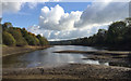
3
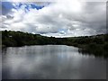
Slaithwaite or Hill Top Reservoir, Slaithwaite
Water level is well below the overflow. The view is from a footbridge over the spillway. Old maps show the outfall feeding mill ponds and mills before passing under the Huddersfield Narrow Canal to join the River Colne, which in turn powered mills. Current information about the reservoir relates to angling, notably for pike. The reservoir features in one of the Milestone Society's walks: http://www.milestonesociety.co.uk/weatherSummerwine/summerwine.html
Image: © Robin Stott
Taken: 22 Oct 2016
0.08 miles
4
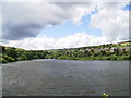
Slaithwaite or Hill Top Reservoir
The reservoir is fed by a brook through Merry Dale Clough, behind the camera Image Rain awaited.
Image: © Robin Stott
Taken: 22 Oct 2016
0.09 miles
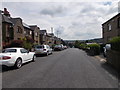
5
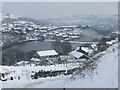
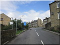
View of Slaithwaite reservoir & the village
This view along Holme Lane shows the reservoir and the Hill Top area of Slaithwaite
Image: © Pamela Norrington
Taken: 3 Feb 2009
0.09 miles
6
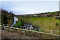
Slaithwaite, Hill Top
View towards Holme Lane from a Trans-Pennine train.
Image: © David Dixon
Taken: 5 Jan 2015
0.13 miles
7
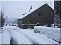
Blakestones, Slaithwaite
The hamlet of Blakestones sits alongside the trans-Pennine rail link.
Image: © Pamela Norrington
Taken: 22 Dec 2009
0.14 miles

9
Longlands Road - viewed from Longlands Avenue
Image: © Betty Longbottom
Taken: 26 Jul 2016
0.16 miles