IMAGES TAKEN NEAR TO
/Binn, HUDDERSFIELD, HD7 5TU
Introduction
This page details the photographs taken nearby to /Binn, HD7 5TU by members of the Geograph project.
The Geograph project started in 2005 with the aim of publishing, organising and preserving representative images for every square kilometre of Great Britain, Ireland and the Isle of Man.

There are currently over 7.5m images from over14,400 individuals and you can help contribute to the project by visiting https://www.geograph.org.uk
Image Map
Images are licensed for reuse under creativecommons.org/licenses/by-sa/2.0
Notes
- Clicking on the map will re-center to the selected point.
- The higher the marker number, the further away the image location is from the centre of the postcode.
Image Listing (12 Images Found)
Images are licensed for reuse under creativecommons.org/licenses/by-sa/2.0
Image
Details
Distance
1
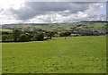
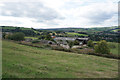
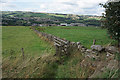
Field with a view, Linthwaite
Taken from the junction of Holt head Road and Jerusalem Road. The building at the bottom of the field (in the next square) is Park. Beyond it is another house with the equally terse name of Binn. The valley side is convex, so that the view passes right over the U-shaped valley floor to the far hillside, with the ribbon development along Longlands Road, Slaithwaite, to the right, and the open countryside of Bradshaw to the centre and left.
Image: © Humphrey Bolton
Taken: 16 Aug 2007
0.12 miles
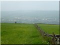
3
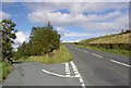
Holt Head Road, Linthwaite and Meltham
This was the first turnpike road from Huddersfield to Manchester. Eventually another was constructed down in the valley, and became the A62. The 'Old Turnpike Road' is mentioned in the Meltham enclosure award as being the far end of some of the roads set out by the award. The boundary between Linthwaite and Meltham is along the road for a considerable distance, so was perhaps undefined across moorland before the road was built. The road going off to the left is Jerusalem Road.
Image: © Humphrey Bolton
Taken: 16 Aug 2007
0.17 miles
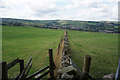
4
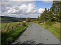
Jerusalem Road, Linthwaite
This is the top end of a lane that climbs up from the Holywell area of Linthwaite via Lower and Upper Clough and High House. It takes its name from a house called Jerusalem, the roof of which can just be seen in the distance.
Image: © Humphrey Bolton
Taken: 16 Aug 2007
0.17 miles
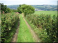
6
Field path towards Linfit Lane
View after crossing Jerusalem Road with Slaithwaite in the mist ahead.
Image: © Kevin Waterhouse
Taken: 12 May 2024
0.19 miles
8
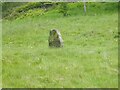
Isolated stone in field
From old OS maps this stone is near the Meltham & Linthwaite border, but this stone is not marked as such. Seen from Holt Head Road.
Image: © Kevin Waterhouse
Taken: 12 May 2024
0.21 miles
10
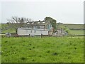
Renovations at Holme Farm
Seen from Holt Head Lane, presumably a residential conversion run from the giant caravan.
Image: © Kevin Waterhouse
Taken: 12 May 2024
0.22 miles