IMAGES TAKEN NEAR TO
Stuart Grove, HUDDERSFIELD, HD7 5LL
Introduction
This page details the photographs taken nearby to Stuart Grove, HD7 5LL by members of the Geograph project.
The Geograph project started in 2005 with the aim of publishing, organising and preserving representative images for every square kilometre of Great Britain, Ireland and the Isle of Man.

There are currently over 7.5m images from over14,400 individuals and you can help contribute to the project by visiting https://www.geograph.org.uk
Image Map
Images are licensed for reuse under creativecommons.org/licenses/by-sa/2.0
Notes
- Clicking on the map will re-center to the selected point.
- The higher the marker number, the further away the image location is from the centre of the postcode.
Image Listing (117 Images Found)
Images are licensed for reuse under creativecommons.org/licenses/by-sa/2.0
Image
Details
Distance
4
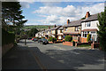
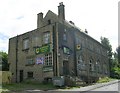
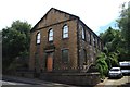
Wesleyan Sunday School, Manchester Road A62, Linthwaite
Disused as a chapel or school, and possibly now a house. The Centenary Chapel is on the right.
Image: © Humphrey Bolton
Taken: 3 Apr 2008
0.06 miles
5
Slaithwaite Saracens Amateur Rugby League Club - Commercial Street
Image: © Betty Longbottom
Taken: 8 Aug 2008
0.08 miles
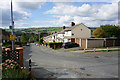
6
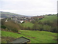
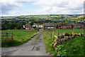
Across Kitchen Clough to Slaithwaite
Looking north east from Varley Road across Kitchen Clough to Slaithwaite, Manchester Road A62 and the River Colne run in the valley behind the houses.
Image: © Sue Trescott
Taken: 2 Jan 2006
0.08 miles
7
Linfit Lane, Linthwaite
This lane winds its way steeply up the hillside from Linthwaite Hall. Here it is lined with houses and bungalows.
Image: © Humphrey Bolton
Taken: 16 Aug 2007
0.09 miles
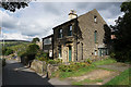
8
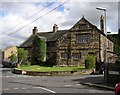
Linthwaite Hall, Linfit Lane, Linthwaite
The listing details state that this is a former manor house built c.1600, with a 'slightly later' north-east (left in the image) extension. These halls were generally built by men who had made their fortune in the wool trade and become minor gentry. There is a former barn out-of-sight between the hall and the modern houses. This has the remains of a cruck frame, but unfortunately the walls and roof were destroyed in a fire in the 1940s and replaced by modern materials. The name 'Gordon Street' in the right foreground is a renaming of the western part of Banks Road.
Image: © Humphrey Bolton
Taken: 16 Aug 2007
0.10 miles
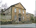
9
Centenary House
Formerly a Wesleyan School the building now has another use, but it is not clear what that is.
Image: © Graham Hogg
Taken: 24 Jul 2013
0.10 miles
10
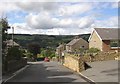
Road leading to Stockerhead Lane, Slaithwaite
Image: © Ian S
Taken: 5 Sep 2018
0.11 miles